

PIX4D survey
PIX4D survey
Couldn't load pickup availability


Bridging the gap between photogrammetry and CAD


Acquisition of images or point clouds with a drone or any laser scanner.
When using a drone, you can automate and optimize your flights with the free PIX4Dcapture mobile application.

Import data from other Pix4D software or a .las or .laz file into PIX4Dsurvey and combine multiple datasets into the same project.

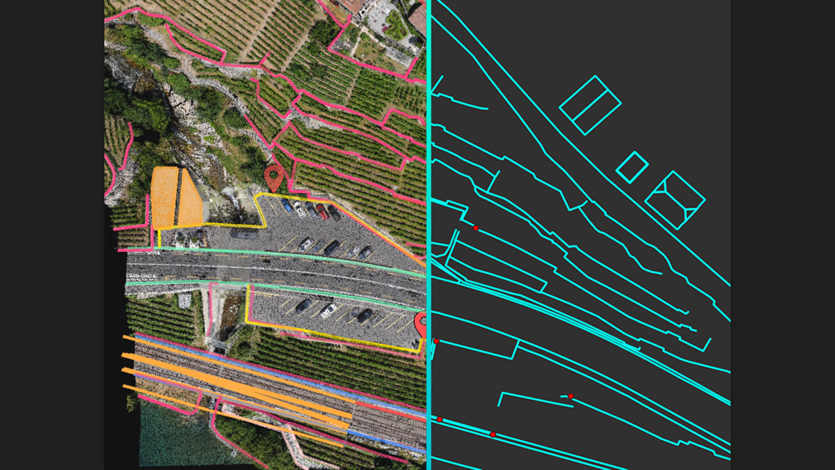
Generate a TIN to model terrain and create engineering-ready CAD vector files from point cloud data by extracting key elements of your project with PIX4Dsurvey.
Work with both image data and LiDAR point clouds.

Go from a lightweight point cloud to a model of your terrain. Use Smart Grid, TIN and terrain classification to get precise, actionable results.

Open your simplified, accurate data in any CAD or GIS software with custom layers and properties that fit your existing workflow.
Besides the point
Extract only the most relevant information to speed up and simplify your survey workflows


Choice of point cloud
Import projects from PIX4Dcloud, PIX4Dmatic, PIX4Dmapper or any .las or .laz file.


From point cloud to TIN in a fraction of time
It automates the creation of point reports and allows a drastic simplification of the number of points in the point cloud. With a simple click, you can use this point grid to model the terrain with a TIN .
Extract the same points you would use in the field with Smart Grid - it doesn't create any data, but reads the terrain class to locate elevation change points, just as the field team would do to take elevations along breaklines .
The next step? Take that set of points and breaklines and create a DTM in LandXML format that exactly reflects the points you told it to use. Now you are ready for your CAD or GIS!
Can I try PIX4Dsurvey?
Can I purchase one month at a time?
How does the floating license work?
What are Personal Support and Updates?
For monthly or annual subscriptions, it is automatically included for their entire duration. For perpetual licenses, it is included for the first 12 months after purchase.
*S&Us can be purchased and renewed annually at 10% of the regular list price and 15% of the regular list price if the renewal deadline is missed
Do you offer training?
What if I have technical questions?
Can I change or cancel my subscription?
You can cancel or change your subscription at any time from your Pix4D. user accounts . Any downgrade changes, including cancellations, will only be reflected at the end of the then-current billing cycle. If you cancel your subscription, it will not automatically renew and you will not be charged at the end of the current billing cycle. We do not offer refunds.
Shipping and Warranty
Shipping and Warranty
All products available in stock will be delivered with an average timing of 24/48 hours.
Italy warranty with dedicated consulting support, contact us!

Contacts
-
Free shipping, return in 14 days *.
DisclosureFree express shipping for orders over € 499.
* For return terms and conditions, please visit our returns and refunds policy.
-
-
Are you a professional or a company?
Contact usYou can ask us for an invoice for your purchases! All the prices of our products already include VAT.
-
Do you have the teacher's card?
Contact usProceed with checkout and select "Teacher's Card" as the payment method. Requests?