FJD Trion V4E LiDAR Kit – 3D LiDAR Scanner
FJD Trion V4E LiDAR Kit – 3D LiDAR Scanner
Couldn't load pickup availability


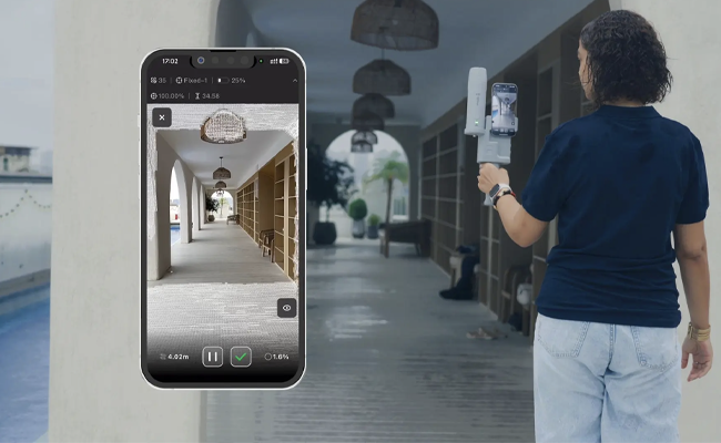
3D surveying now starts from your smartphone
Connect your smartphone to the V4E LiDAR Kit and get georeferenced point clouds in real time.
One kit, two solutions
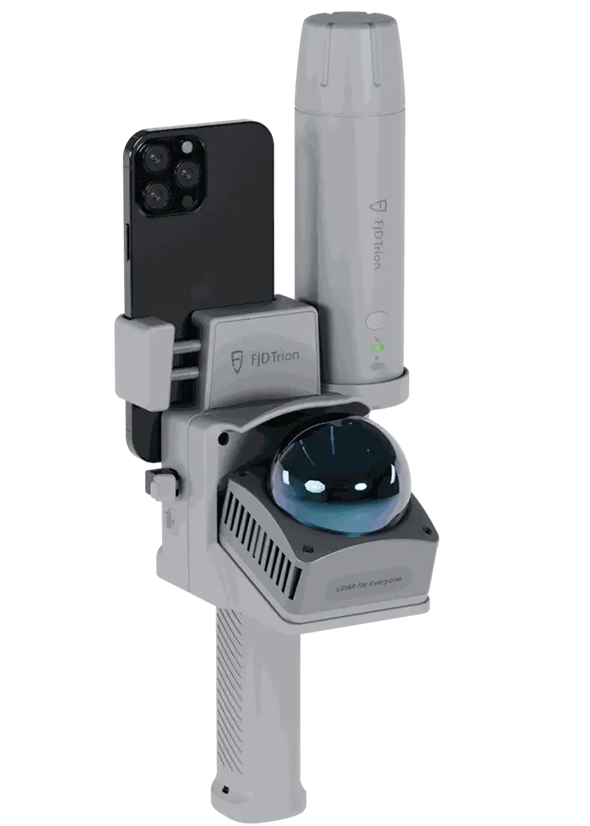
V4E LiDAR Kit with GNSS
The hybrid GNSS RTK and LiDAR system for real-time georeferenced 3D scans.
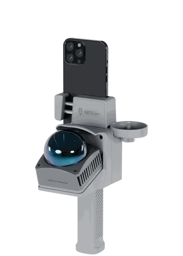
V4E LiDAR Kit
LiDAR accessory for those who already own a V4E receiver or for indoor surveys.
Precise scanning with every pass
Capture 154,600 points per second for a denser, more uniform point cloud even when walking at a brisk pace. The LiDAR has a scanning range of 50 m, so you can detect details and geometries with greater confidence. Plus, you see a real-time preview directly on your smartphone as you scan.


Portable yet powerful
Say goodbye to bulk and fatigue: with a main unit weighing just 890g, the V4E LiDAR remains light in hand and comfortable to use without slowing you down in the field.
Plug & Play: ready to use in 60 seconds
The FJD V4E LiDAR Kit is designed to get you started right away: quick setup and operation in under a minute, so you go from opening the case to your first scan in no time, without complicated procedures. Once started, you can count on over 5 hours of battery life, perfect for construction sites, inspections, and extensive surveys without interruptions or continuous recharging. All this in a compact and practical system, designed to work continuously and with the same simplicity even if it's your first experience with 3D scanning.
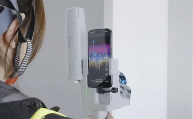
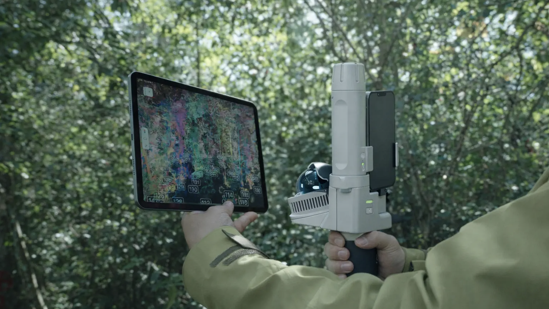
Reality digitized as you walk
During scanning, you can view a real-time preview directly on your smartphone: as you walk, the point cloud takes shape before your eyes and the environment transforms into its digital twin. This way, you immediately check coverage and quality, correct any missing areas on the spot, and complete the survey with more confidence, without having to "find out later" if something is missing.
Scan everywhere
From the narrowest interiors to open spaces, V4E LiDAR allows you to work more calmly in different and variable contexts. It is a solution designed to accompany you in the field with practicality and continuity, so you can say "yes" to more projects and face every survey with more confidence.

Complete Solution for Point Clouds
Field and Office Software
FJD Trion Scan
Real-time point cloud visualization software for field use
Enhance your scanning experience with FJD Trion Scan software. This real-time visualization tool can help you monitor the scanning process, ensuring complete data acquisition in one scan.
Available on
FJD Trion Model
Point cloud processing software for office use
FJD Trion Model is a PC-based point cloud processing solution that enables denoising, colorization, and classification. Industry-specific modules allow for quick and seamless results for floor plan generation for construction, volume calculation for tunnels, and tree segmentation for forestry.
FJD Trion Model for Tablet
Result Generation
iPad and Android support. On-site post-processing and preview.
Available on
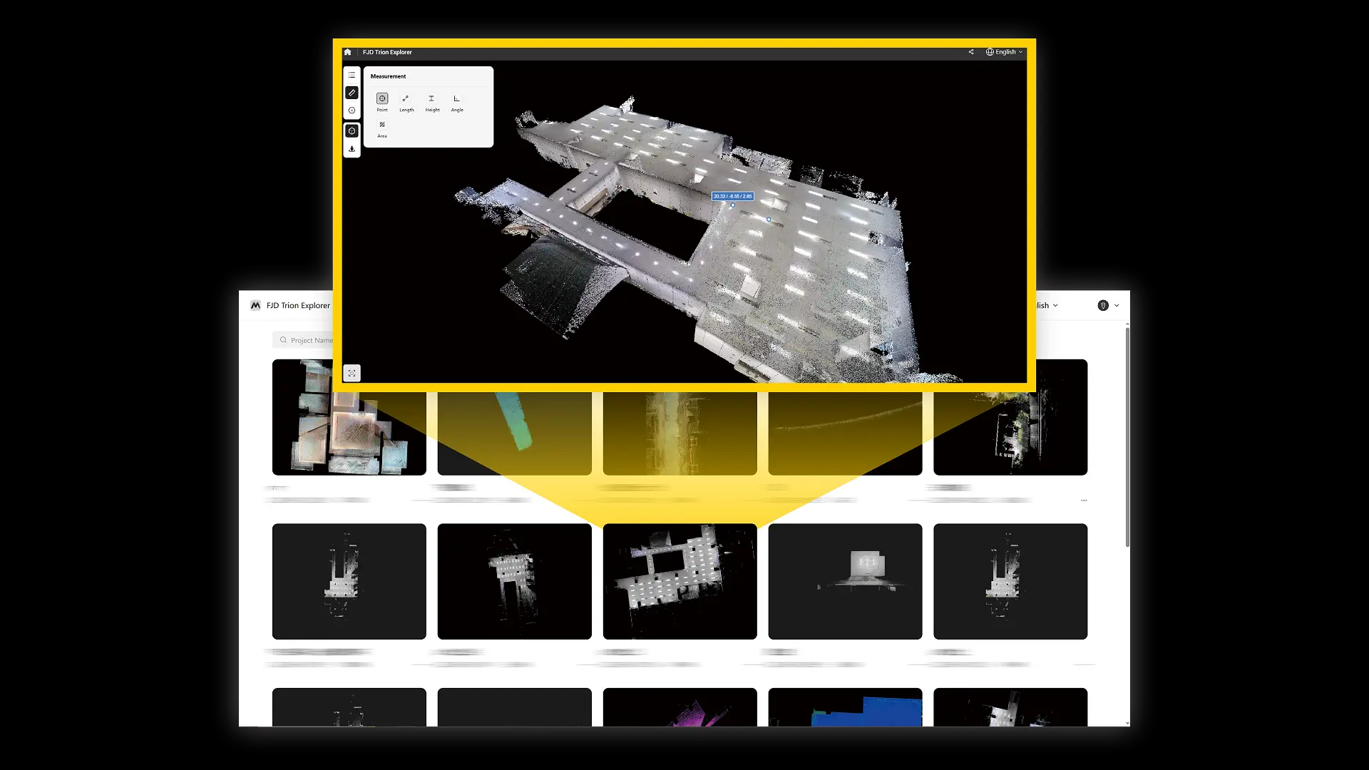
FJD Trion Explorer
Share and collaborate
Share online and support collaboration among teams.
Designed for teams at every stage
Have you never tried 3D scanning and want to bring more clarity to your projects? V4E LiDAR is the simplest way to enter the world of professional reality capture, with an immediate and uncomplicated workflow. Do you already have experience in the sector? V4E LiDAR offers solid and reliable performance to help more structured teams work faster, reduce operational costs, and increase productivity, keeping everything simple and without adding complexity to the process.

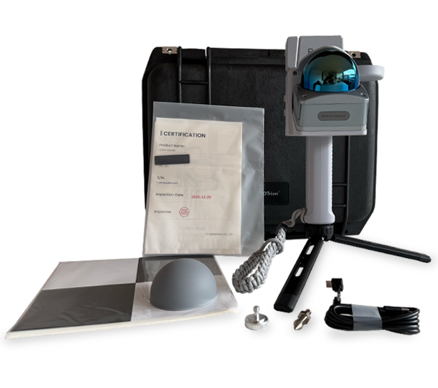
FJD V4E LiDAR Kit
In the box:
- V4E LiDAR Kit
- Silicone cover
- Tripod
- Type-C cable for smartphone connection
- Charging cable
- Adhesive targets
- Rope lanyard
- Pointed screw
- Screw for GNSS attachment to LiDAR Kit
- Certificate
- RTK V4E/V4E Pro Antenna (depending on the chosen package)
LiDAR Technical Specifications
| Category | Specification | Value |
|---|---|---|
| General | Eye Safety Rating | Class 1 according to IEC 60825-1:2014 |
| General | Minimum Detection Distance | 0.05 m |
| General | Field of View FOV | Horizontal 360° / Vertical from -10° to +60° |
| General | Real-time Point Cloud Accuracy | Up to 5 cm |
| General | Post-processed Point Cloud Accuracy | Up to 3 cm |
| General | Sampling Frequency | ≥ 200 kHz |
| General | Point Cloud Output | 154,600 points/s at 70° vertical field of view |
| Electrical and Interface | Charging Specifications | 5V / 3A |
| Electrical and Interface | Lithium Battery | 3.6 V / 6700 mAh |
| Electrical and Interface | Charging Time | ≤ 3 hours |
| Electrical & Interface | Operating time | ≥ 5 hours |
| Electrical & Interface | Data port | USB 3.0 |
| Electrical & Interface | Charging port | USB 2.0 Type-C |
| Electrical & Interface | Firmware update | Via charging port / USB 2.0 |
| Physical Characteristics | Dimensions | 137 × 155 × 250 mm |
| Physical Characteristics | Weight | Approx. 890 g |
| Physical Characteristics | Mounting interface | 5/8" internal thread |
| Physical Characteristics | Operating temperature | -10°C to +60°C |
| Physical Characteristics | Charging temperature | 0°C to +45°C |
| Mobile Compatibility | iOS | iPhone 15 and later models |
| Mobile Compatibility | Android | Galaxy S20 and later models |
Technical Specifications GNSS FJD Trion V4E / V4E Pro Mini RTK
| Category | Specification | Value |
|---|---|---|
| GNSS | Channels | 1408 channels |
| GNSS | GPS | L1C/A, L2P, L5 |
| GNSS | GLONASS | G1, G2 |
| GNSS | Galileo | E1, E5a, E5b, E6 — supported by specific firmware |
| GNSS | BDS | B1I, B2I, B3I, B1C, B2a, B2b — supported by specific firmware |
| GNSS | QZSS | L1, L2C, L5 |
| GNSS | SBAS | L1C/A |
| Data | Differential data | RTCM 2.3, RTCM 3.x, CMR |
| Data | Data format | NMEA-0183 |
| Electrical & Interface | Charging specifications | 5V / 2A |
| Electrical & Interface | Power consumption | ≤ 1.5 W |
| Electrical & Interface | Electrical interface | USB 2.0 Type-C |
| Electrical & Interface | Charging time | ≤ 3 hours |
| Communication | Bluetooth | BT 4.0 dual mode |
| Communication | Bluetooth working distance | 5 m |
| Physical Characteristics | Shell material | PC + ABS |
| Physical Characteristics | Button | On / Off |
| Physical Characteristics | Operating temperature | -20°C to +60°C |
| Physical Characteristics | Protection rating | IP67 |
| Physical Characteristics | Mounting interface | 1/4" internal thread |
| Physical Characteristics | Charging temperature | 0°C to +45°C |
Important technical note on georeferencing
The GNSS RTK allows scanning to be positioned in real coordinates when the satellite signal is available and stable. In indoor, underground, or shielded environments, the GNSS component may be limited: in these cases, the survey can still be used as a local point cloud, but known points, targets, topographical constraints, or a subsequent registration process are needed for absolute alignment.
Thanks to RTK, the FJD V4E LiDAR Kit transforms outdoor 3D scans into real coordinates, generating a georeferenced point cloud that integrates and aligns precisely with floor plans, layouts, and subsequent workflows.
The post-processing accuracy is 3 cm: a value referring to the final result after processing, while relative accuracy describes the consistency between points/portions of the same scan.
The system acquires up to 154,600 points per second with a range of up to 50 m (at 90% reflectivity) for fast and detailed scans even outdoors.
With a single acquisition, you can export point clouds, BIM files, meshes, and other outputs using FJD Trion Model.
Shipping and Warranty
Shipping and Warranty
All products available in stock will be delivered with an average timing of 24/48 hours.
Italy warranty with dedicated consulting support, contact us!