EMLID REACH RS4
EMLID REACH RS4
Couldn't load pickup availability


Emlid Reach RS4 is a next-generation multi-frequency RTK GNSS receiver designed for topographic surveys, GIS, and precision agriculture, offering centimeter-level accuracy even under dense canopy and in challenging environments. Thanks to its high-performance antenna, tilt sensor with integrated IMU, and radio, LTE, and NTRIP connectivity, it enables fast, reliable, and highly productive operations on the construction site.
Product Overview
Reach RS4 is an all-band RTK GNSS receiver capable of tracking all major constellations (GPS, GLONASS, Galileo, BeiDou, QZSS, NavIC) on L1, L2, L5, and L6 bands, with 672 dedicated channels. The unit is designed to provide fixes in less than 5 seconds, maintaining the solution even in the presence of multipath, vegetation, or complex urban environments.
The next-generation IMU-based tilt compensation allows you to measure points with the pole tilted without losing operational accuracy, reducing stationary time and facilitating surveys in difficult-to-reach locations. The IP68-rated magnesium alloy body ensures robustness, shock resistance, water resistance, and dust resistance, making the RS4 suitable for construction sites, agricultural environments, and extreme weather conditions.
Usage and applications
Reach RS4 is ideal as an RTK rover connected via NTRIP or as a base/rover pair via integrated UHF/LoRa radio, covering both mobile surveys and local reference stations. It is used for topographic surveys, construction site layouts, high-accuracy GIS surveys, precision agriculture, and infrastructure projects where reliable and repeatable data is required.
Integration with Emlid Flow and leading GIS and construction site apps enables seamless workflows for managing points, lines, and surfaces, as well as exporting to industry-standard formats. The combination of multiple connectivity options, extended battery life, and advanced tilt makes the RS4 ideal for surveying teams requiring high productivity with rapid setup.
Main technical specifications
GNSS and performance
-
Constellations traced:
TILT and sensors
-
Tilt compensation: Based on next-generation integrated IMU, optimized for quick initialization and intuitive use.
-
Operation with tilted pole, allowing the survey of difficult-to-access points while maintaining RTK accuracy.
Mechanics and robustness
-
Operating temperatures: approximately −40 to +65 °C, suitable for extreme climates.
-
Quick Release Mount: Quick pole mount with standard 5/8″ thread, designed for secure attachment even with tilted pole.
Power supply and autonomy
-
Autonomy: up to 16 hours of continuous work as an RTK rover with TILT active.
-
High-capacity internal battery (approximately 7000 mAh) with USB Type-C charging.
-
USB-C charging support with compatible power adapters and power banks.
Data connectivity
-
LoRa Radio:
-
UHF Radio:
-
Position output: NMEA, LLH/XYZ, with logging in RINEX, NMEA, LLH/XYZ, UBX on internal memory.
-
Internal memory: 16 GB for recording still and cinematic sessions.
-
Interfaces:
Emlid Reach RS4 Technical Specifications Table
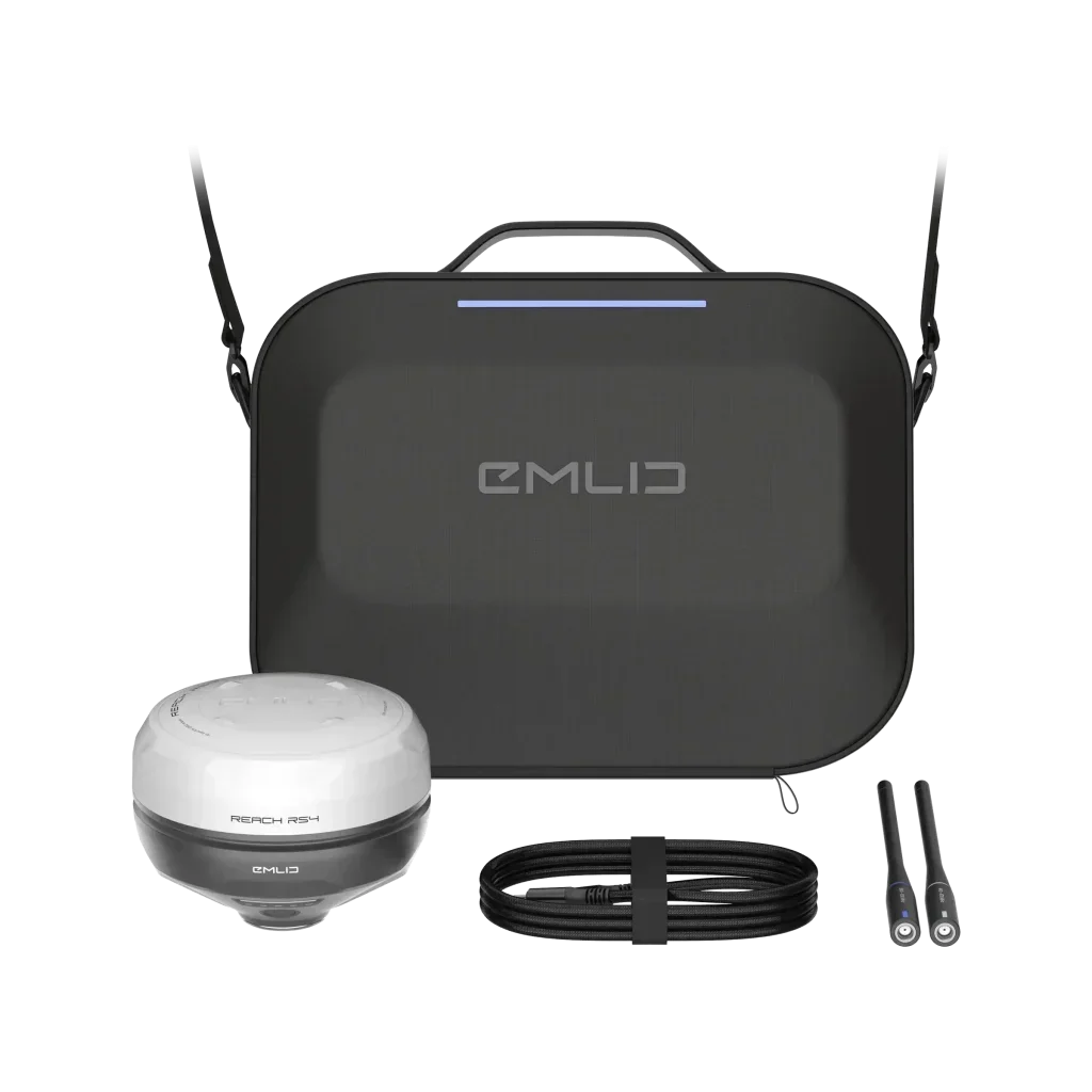
Package Contents
The Emlid Reach RS4 kit comes complete with everything you need to get started in the field with quick and secure setup. The included accessories are selected to take advantage of both the built-in LoRa and UHF radios, as well as ensuring easy transportation and charging.
The package includes
-
Carrying case, designed to protect your receiver and accessories while traveling.
-
LoRa 860–930 MHz antenna for use with the integrated LoRa radio.
This configuration allows Reach RS4 to be used either as an NTRIP rover or as part of a radio base/rover solution, easily integrating it into existing surveying and GIS workflows.
Shipping and Warranty
Shipping and Warranty
All products available in stock will be delivered with an average timing of 24/48 hours.
Italy warranty with dedicated consulting support, contact us!