

Drone detection has become increasingly popular in recent years.
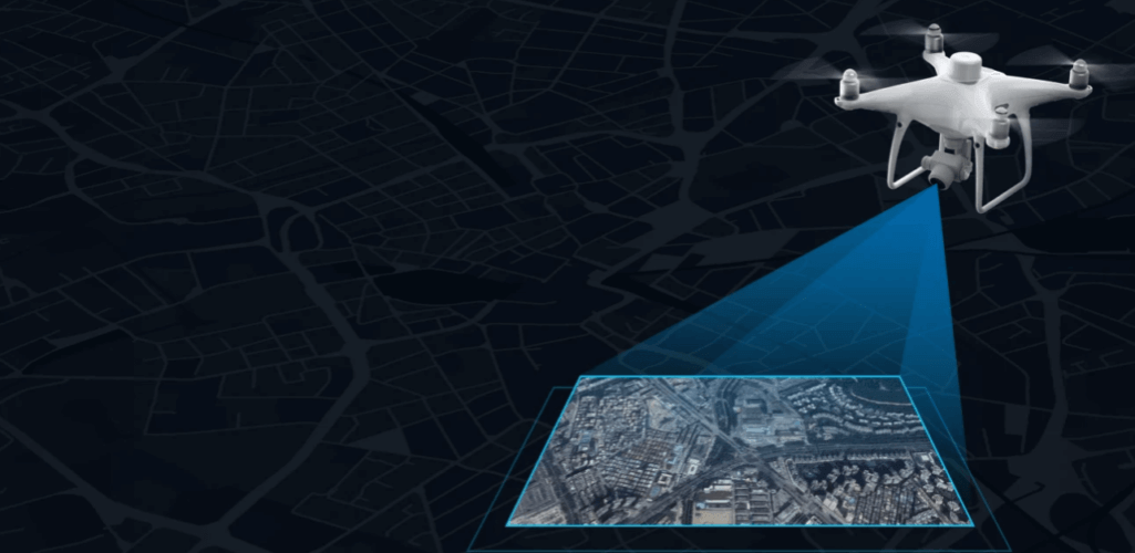
Aerial mapping with unmanned aircraft is helping teams gather valuable aerial information quickly, efficiently, safely and at an affordable price, while helping to shape decision making, improve communication, and drive revenue and results.
As the trend of drones for detection accelerates, there is a question that arises regularly: what is the best method of data collection: LiDAR or photogrammetry ?
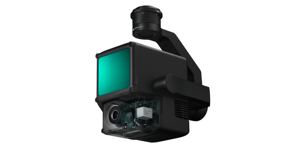
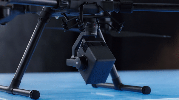
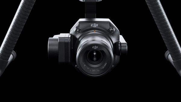
The recent release of DJI's L1 and P1 mapping payloads shows the growing interest and demand for these two aerial mapping practices; the L1 (below, right) is a LiDAR sensor (with photogrammetry capabilities), while the P1 (below, left) is a dedicated photogrammetry payload with a high resolution 45MP full frame sensor.
It seems pertinent, therefore, to compare these two aerial mapping methods. Which ones are they? What are their advantages and disadvantages? When should you use them? And is one better than the other?
What is LiDAR?
LiDAR stands for light detection and distance.
So how does LiDAR work? LiDAR, also known as 3D laser scanning, works by sending pulses of light to the Earth's surface or an element on it and measuring the time it takes to reflect.
The time it takes to return to the LiDAR source indicates the exact distance to the object or feature. This is known as the Time of Flight (ToF) principle.
This provides an accurate positioning point of where the laser hit the earth's surface. Depending on the sensor used, LiDAR units can emit hundreds of thousands of pulses per second, helping to create a detailed view of what the sensor is focusing on.
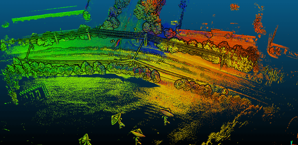
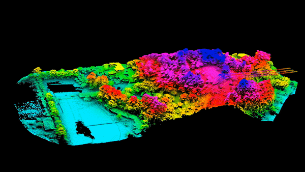
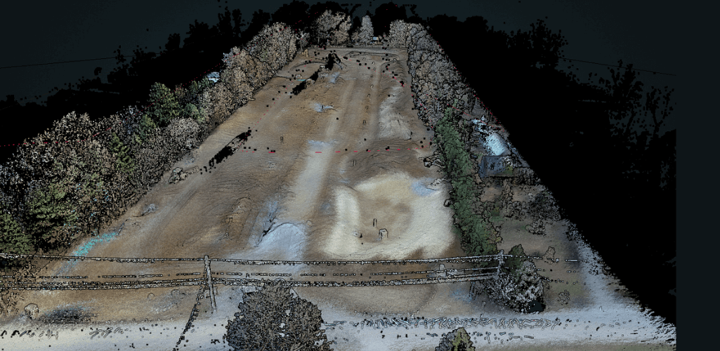
This can then be used to create 3D point clouds; an accurate visualization representing the terrain, topography and characteristics of the scanned area.
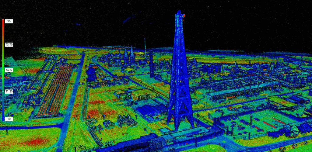
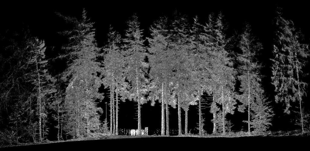
The image above - of Shell's Bacton Gas Terminal, captured with L1 - shows a LiDAR point cloud.
Drone LiDAR has emerged as a useful aerial survey tool for many applications, such as forestry, agriculture and construction.
What is photogrammetry?
Photogrammetry is the art of capturing high-resolution photographs to recreate a prominent area.
These images are processed and merged using sophisticated software to create realistic, georeferenced and measurable 3D models of the real world.
Depending on the software, these digital twins can be fully navigable, helping teams access and assimilate key information quickly and easily.
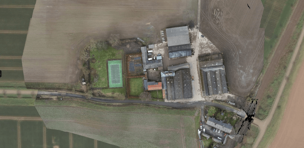
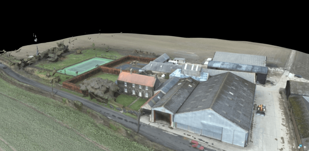
Photogrammetry can also be used to create detailed 2D maps. These orthomosaic datasets provide accurate photographic representations of an area, with georeferenced information.
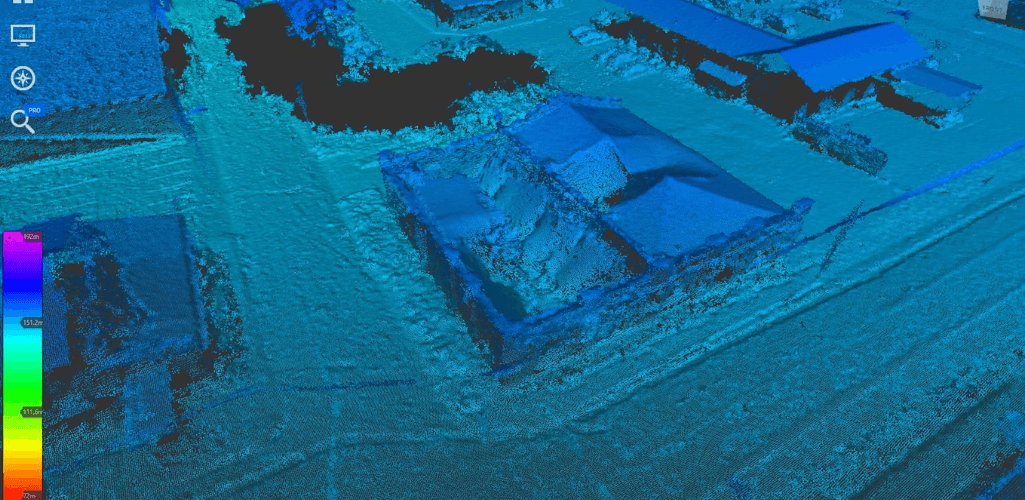
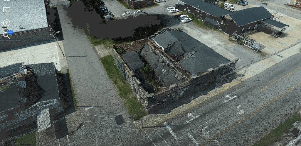
To illustrate this, the first image is a 2D orthomosaic of a farm, while the second image is a 3D model of the site, both captured with the P1 photogrammetric camera.
The number of images needed for valuable photogrammetry datasets ranges from hundreds to thousands, depending on the size of the site and the desired accuracy.
Use cases for photogrammetry are wide-ranging, including project management, crime scene mapping, marketing, performing inventory calculations and measurements, topographic mapping, and building surveys.
LiDAR vs Photogrammetry - Pros and Cons
Like everything, LiDAR and photogrammetry have their good and bad sides.
These factors, together with the mission brief, could determine the preference for both applications.
Versatility of the mission
One of the main advantages of using LiDAR over photogrammetry is the improvement in performance during certain missions.
For example, LiDAR is more effective, and therefore more accurate, in detection areas with high vegetation cover.
How come? Because LiDAR pulses are able to penetrate the spaces between leaves and branches to reach ground level.
Conversely, in traditional photogrammetry, vegetation can prevent you from gaining an accurate representation of what the soil topography looks like.
For this reason, LiDAR is a more accurate solution than photogrammetry for building a digital terrain model (DTM); a model of the bare earth (with no objects / buildings inside it) containing the terrain elevation data.
This dataset, shared with heliguy ™ by Ben Bishop, technical director of Flythru Limited, shows the differences between LiDAR and photogrammetry for ground level acquisition for DTM generation.
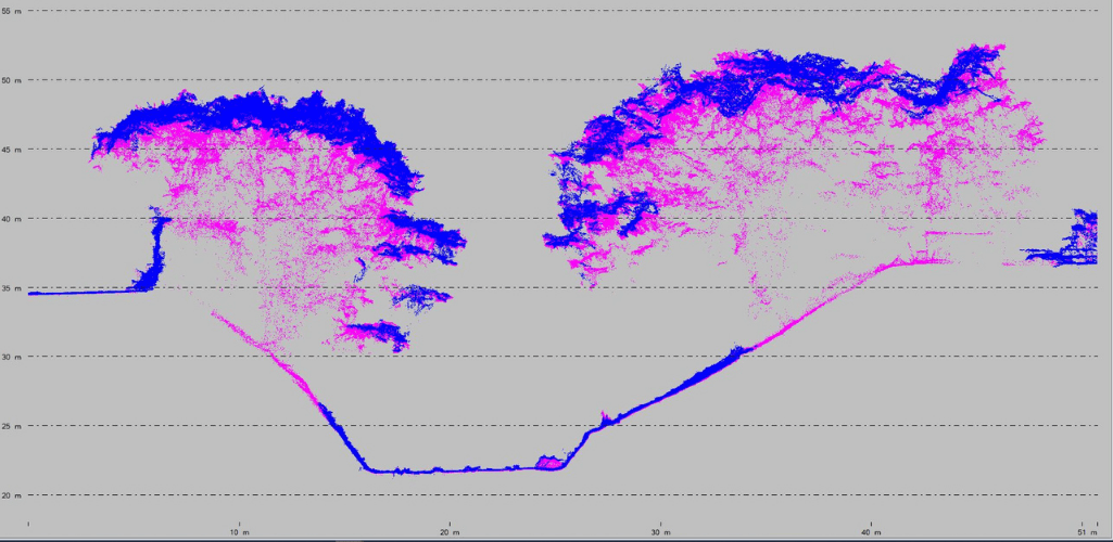
Considering the vegetation density in this example, photogrammetry (blue) did a good job, but the graph shows the advantage of LiDAR (pink) in this situation.
Note, for example, the thick pink line (and the absence of blue) on the ground in areas directly under the trees, demonstrating how LiDAR pulses can hit the ground in areas of high vegetation, as well as that of photogrammetry.
This is different from a Digital Surface Model (DSM) which represents the earth's surface and includes all objects on it. Both LiDAR and photogrammetry are good solutions for creating DSMs.
One statistic states that LiDAR can penetrate areas with up to 90% vegetation, while photogrammetry is closer to the 60% mark.
It is for this reason that LiDAR has become a favorite of forestry professionals.
Not only is LiDAR more effective in high vegetation areas, it is also better suited for missions performed in low light conditions, or even at night, without the need for an external light source.
Conversely, the results of a photogrammetric drone flight can be severely affected by low light, dust, or cloud cover.
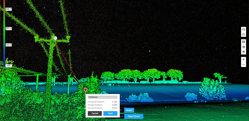
Thanks to the high-density spot sampling and direct measurement nature of LiDAR, it is also more effective for measuring and capturing small / narrow objects, such as power cables, pipelines, and sharp-edged items.
This is demonstrated in these two datasets. Power lines are visible in the center of the left image - captured with the L1 LiDAR sensor - but are not visible in the 2D orthomosaic of the same scene, as captured with the P1 photogrammetry sensor.

For this reason, LiDAR can also be used to collect complex measurements between cables and trees, as the image below shows. as demonstrated by Keltbray in this case study .
Ease of use
Accessibility is one of the biggest differences between LiDAR and photogrammetry.
LiDAR is quite complex and requires a high level of understanding, which can widen the margin for error and increase the demand for an experienced practitioner.
However, the DJI L1 is helping fill this gap by simplifying LiDAR workflows and making them more accessible to more people.
That said, in general, photogrammetry is a simpler detection method.
Yes, there are things to think about, such as which flight height will provide the best sample distance to the ground (more than that shortly) and what image overlay rate is needed to ensure the most accurate model.
But overall, advances in drone photogrammetry have allowed for streamlined workflows, helping to bring accurate maps and models within the reach of any organization with a decent camera drone.
Data set
The difference between LiDAR and photogrammetry datasets is night and day.
A LiDAR dataset consists of thousands of points - or returns - to create a detailed 3D point cloud that outlines the terrain and elevation.
For this reason, a LiDAR dataset does not always create a pleasing image and may require a high level of skill for interpretation. And sometimes, when it comes to detailed surfaces and features, LiDAR can be non-specific, meaning you can be unsure of what you're actually seeing.
That said, you can get a more visually accessible model by using color from separate datasets.
Additionally, some LiDAR systems, including L1, have photogrammetry capabilities to help add more detail to a point cloud and aid cross-referencing. In fact, L1 operators benefit from its ability to generate real-time color point cloud models in real time.
But forget aesthetics for a minute - people who can interpret a LiDAR dataset will know its true value for certain applications.
In contrast, photogrammetry creates models based on hundreds or thousands of real-world images that are stitched together.
For this reason, a 2D map or 3D model created through this sensing technique is instantly recognizable and recognizable, helping teams to access, share and understand digital twins quickly and easily.
Because photogrammetry involves high-resolution images, it is capable of capturing the visual details of every feature of a site and, unlike some LiDAR point clouds, extracts the abstract from a dataset.
For example, these two images of buildings in downtown Henderson, taken by the Henderson City Engineering Department, show the differences between the LiDAR (top image) and photogrammetry (bottom image) datasets. You can read the full case study here.
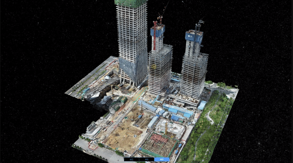
For these reasons - and because a drone survey can acquire repeatable data - photogrammetry has become a crucial tool for aerial visualizations, change tracking and progress tracking on a construction site, for example.
Cost
LiDAR uses lasers, while photogrammetry is based on images collected by a camera.
And traditionally, LiDAR sensors were large, so a bigger plane was needed.
Therefore, photogrammetry has become known as a more cost-effective solution than LiDAR.
However, this gap is narrowing. Take DJI's L1 LiDAR payload for example, which is a cheaper and more compact solution than other LiDAR sensors on the market.
And with continued innovation, there is every chance that LiDAR will continue to become more accessible (in terms of price and application).
LiDAR v Photogrammetry: which is the most accurate?
When it comes to detection, one of the most important considerations is accuracy.
When done correctly, LiDAR and photogrammetry are reliable and accurate methods.
But, before we go into detail, here is the definition of two terms that are an integral part of this section:
- Relative Accuracy (Vertical) : Relative accuracy refers to the accuracy of a dataset's data points with each other. If the distance between point A and point B is 62.128m on the ground, with an overall relative accuracy of +/- 20mm you would expect the model distance to be between 62.126m and 62.130m. Data with relative accuracy WILL be collected with reference to a coordinate reference system, but not with high accuracy.
- Absolute Accuracy (Vertical) : Absolute accuracy refers to the accuracy of the data set in relation to a coordinate system or datum. For example, with an absolute accuracy of 20mm, there would be a margin of error of 40mm (20mm in each direction).
LiDAR accuracy of the drone
When accuracy is critical, LiDAR is an extremely reliable solution.
Remember, LiDAR works by hitting the Earth's surface, or a feature on it, firing laser pulses from above, and measuring the reflection. It therefore represents a direct measure.
This, along with its integration with GNSS data, helps give your digital terrain map high levels of vertical accuracy.
LiDAR is also an ideal solution for achieving absolute precision, especially if the intention is to create a realistic model of bare earth, thanks to its ability to take into account elevation and vegetation.
In fact, thanks to LiDAR's high data point density (with sensors emitting hundreds of points per square meter), surveyors can create a truly robust dataset.
As a side note, when looking at different LiDAR solutions, the frequency of the laser pulses is a key specification. A higher pulse rate collects more measurements per second, creating more detailed patterns and reduces the number of flights required to cover a specific area.
But LiDAR is a complex system and many factors determine accuracy.
It's not just about the LiDAR sensor - other high-precision systems such as satellite positioning (GNSS data) and an inertial measurement unit (IMU) need to be of high quality to build an accurate point cloud that accurately reflects the area of survey, its terrain, topography and characteristics.
But overall, LiDAR tends to produce scans with greater detail and accuracy than photogrammetry.
Accuracy of photogrammetry with drone
However, that doesn't mean photogrammetry isn't an accurate survey solution.
In reverse. In fact, some drone solutions can provide centimeter-level accuracy.
But there are some important factors to consider that can affect accuracy.

For example, the quality of the drone and the camera.
The size of the sensor, its resolution and focal length all affect the sample distance to the ground (GSD) and the required flight altitude.
For the record, GSD is defined as the length (in inches, centimeters, or millimeters) between the centers of two consecutive pixels on the map.
So if a drone achieves a GSD of 5cm / px, this equates to a pixel on the digital map corresponding to 5cm in reality.
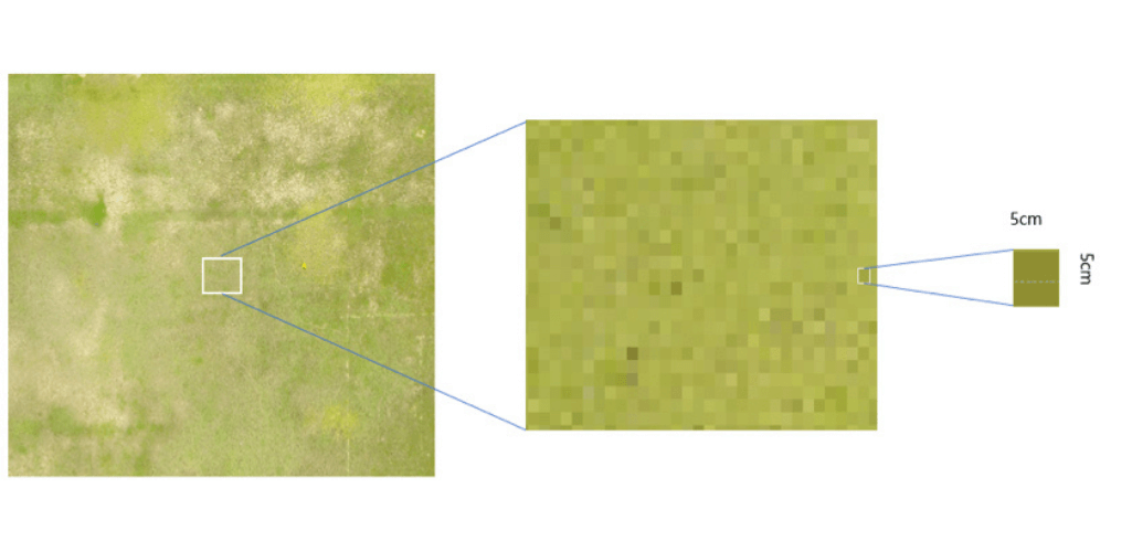
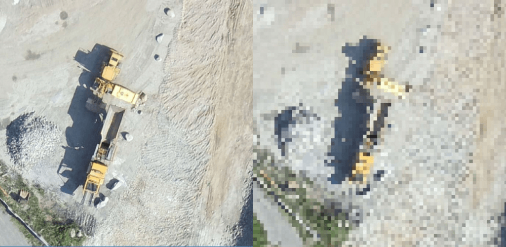
The smaller the GSD, the higher the accuracy. Let's take the images below as an example: The orthomosaic with a GSD of 5 cm (left) is much more detailed than the one on the right with a GSD of 30 cm. This is because the higher the GSD value of the image, the lower the spatial resolution of the image and the less visible the details.
When is it best to use LiDAR Drone?
LiDAR can be a key tool in a surveyor's arsenal.
While it can be used for a wide variety of applications, there are perhaps specific mission types where it is truly unique.
These include:
Mapping of complex soils with vegetation cover
In low light conditions or at night
When it is necessary to detect small / narrow objects such as cables or pipes, which may not be detected or be recognized by alternative methods.
LiDAR is also an effective method when accuracy is particularly crucial and for projects where accuracy is a priority.
When is it best to use drone photogrammetry?
More and more companies, organizations and departments across a growing range of verticals are embracing drone photogrammetry.
And there are some scenarios that are perfectly suited to this aerial survey technique. These include:
Data sets that require visual evaluation
Projects that require easy-to-understand maps and models
Context-rich scans that are accessible and require minimal experience and post-processing.

A 2D map or 3D model can be invaluable for tracking progress on a construction site, improving communication between teams and stakeholders, city planning and management, and checking for errors / damage.
LiDAR drone and photogrammetry: what solutions are available?
Numerous solutions are available in the DJI ecosystem to help collect LiDAR data and photogrammetry.
Click for more information on LiDAR drones and LiDAR scanners.
LiDAR drone
DJI's flagship commercial platform, the M300 RTK, can be used as a LiDAR drone thanks to the release of the Zenmuse L1 sensor.
L1 integrates a Lidar module, a 20MP RGB camera and a high-precision IMU.
Its main features include:
- Highly efficient, it can cover up to 2km² in one flight
- Degree of protection against bad weather IP54
- It supports three returns
- Points rate of 240,000 points / s
- Vertical accuracy of 5cm / Horizontal accuracy of 10cm
- Detection range 450 m
- LiveView point cloud
The M300 RTK and L1 can also be used in conjunction with DJI's mapping software platform, DJI Terra. This allows surveyors to access 3D data, details of complex structures and precise visual reconstructions. Terra is also highly efficient when it comes to processing LiDAR L1 data.

Drone Photogrammetry
M300 RTK and Zenmuse P1
The M300 RTK can be integrated with the Zenmuse P1 camera. This payload has a 45MP full frame sensor, making it a highly capable solution for photogrammetry.
Other key features include:
- Capable of achieving accuracy of 3cm horizontally and 5cm vertically, without GCP
- Highly efficient, it covers 3 km² in a single flight
- 3-axis stabilized gimbal with Smart Oblique Capture, ideal for large detection sites
- Global mechanical shutter with a shutter speed of 1/2000 seconds
- TimeSync 2.0, allows synchronization at the microsecond level
- Interchangeable fixed focus lenses (24/35/50 mm)
- An update also allowed the P1 to be used in conjunction with DJI's Terra mapping solution.
Phantom 4 RTK
The Phantom 4 RTK is DJI's low-altitude mapping solution. It is particularly suited to small surveying areas, but, because of its accessibility, it offers a good introduction to those who are new to drone surveying.
Its main features include:
- RTK module
- 1 ″ 20MP CMOS sensor
- The mechanical shutter reduces the risk of blurring of the rotating shutter
- TimeSync system, which aligns the flight controller, camera and RTK module
- LiDAR v Photogrammetry: which is the best?
- There's a good reason LiDAR and photogrammetry have become popular drone sensing techniques - they can capture quality data and provide valuable information.
But which is the best?
In truth, it's a difficult question to answer, because they both have their values.
In many ways, it boils down to the work at hand.
LiDAR is extremely powerful for specific missions, such as demanding projects where elevation accuracy, complex structures or areas involving tall vegetation are critical.
Thanks to innovation, such as DJI's new L1 payload, LiDAR is becoming more accessible and affordable, but the fact remains that it is a highly specialized sensing technique.
Therefore, for broader detection needs, photogrammetry will be more than adequate - it is generally cheaper, more accessible, and, when done correctly, is accurate enough to meet most needs.
And for teams that need a highly visual digital asset, drone photogrammetry is a powerful aerial survey method.

But regardless of your preferred technique, innovation in both fields is exciting; a fact exemplified by DJI's new L1 and P1 sensors.
Continued growth in these areas will only improve the ability of air surveyors to acquire highly detailed and accurate maps and models, faster, safer and cheaper than before.