
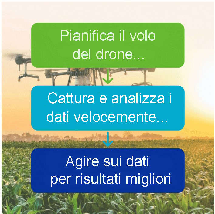
WHY USE DRONES IN AGRICULTURE?
New generation agriculture.
Precision farming is a game changer
For centuries, farmers have walked their fields monitoring the health of their crops. It is a time-consuming process. But this is changing.
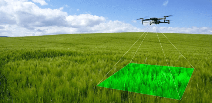
Agricultural drones are becoming a key factor in helping farmers increase agricultural production, monitor and inspect crop growth, create a richer picture of their fields, improve agricultural efficiency and maximize results.
Among the many benefits, drone data can be used to extract soil characteristics, including temperature, humidity, and elevation, which aids in more accurate soil sampling.
Drones and their sophisticated sensors can help farmers plan and troubleshoot irrigation systems, helping with the management and use of water flow; monitor the emergence and population of plants to guide replanting decisions and improve crop models; and decide on harvest plans by helping farmers to anticipate crop quality and final yield.
On-demand, high-resolution drone data is also perfect for accurately capturing and reporting events that lead to economic losses, such as crop damage and reduced health.
Drones cover areas faster, offer real-time insights, are more accurate than traditional methods, and don't bypass crops.
Simply put, drones provide vital data that helps farmers and growers monitor, plan and manage their farms more effectively, saving time and money in the process.
Up to 40 hectares
covered in a working day with a drone when the fields are close together.
Cost reduction up to 85%
when using 3D field mapping and soil analysis with drones.
1.3 billion dollars a year
could be saved by corn, soybean and wheat farmers using drones, a study says.
4.8 billion dollars
is the expected figure that will reach the agricultural drone market by 2024.
How can drones be used in agriculture?
The versatility of drones and their sophisticated sensors allows farmers to use the technology for a variety of reasons. These include:
- Crop monitoring : Drones monitor crops accurately and economically compared to traditional methods and offer key information on crop development, as well as highlight inefficient and ineffective practices.
- Soil and field analysis : Drones can produce 3D maps, quickly and economically, which help farmers make important decisions about planting pattern design and nitrogen level management, for example.
- Health Assessment : Drones can acquire multispectral data to help farmers gather key information on crop health. Such timely intervention is essential to remedy any problems.
- Irrigation : Drones equipped with monitoring equipment can identify areas of a field subject to water stress (lack of water). Thermal sensors provide crucial information, enabling targeted diagnosis of areas receiving too much or too little water.
- Aerial Planting : Drones can fly over a potential planting area to monitor the best areas for growth. They can then release biodegradable pods, full of seeds and nutrients, into the soil.
- Herd Management : Farmers are employing drones to monitor livestock. In some cases, drones with speakers, such as the DJI Mavic 2 Enterprise series, are used for the movement of animals, reproducing the barking of a pre-recorded dog. Breeders say this method puts less stress on the herd.
- Crop spraying : Crops can quickly cover large areas, applying liquids with great precision.
- Insurance : drones can play a key role in insurance, both in the pre- and post-accident phase. Using a drone helps with site inspection, complaint decisions, fraud prevention and risk management.
“Some of my experts have told me it's almost as if using the drone is some sort of unifying force in the relationship between them and the farmer. The farmer likes that they are here and use something so precise and cutting edge in their fields. "
Philippe Vayssac, Groupama Rhone-Alpes Auvergne
“There is a huge appetite for drones in agriculture and livestock. A drone can be transformed into a useful agricultural tool, flying over a field to provide a farmer with valuable information and a range of information and make walking fields a thing of the past. "
Jack Wrangham, Drone AG
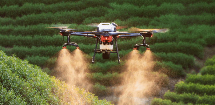
DRONES FOR SPRAYING CROPS
Automated, targeted and precise.
A safe and efficient solution
Agricultural drone spraying is becoming an increasingly popular application, helping to maintain crop health and yield.
Drones are used to spray diseases, weeds and pest control, as well as spread pesticides and fertilizers.
Using drones for this application makes sense, offering a fully automated, focused and precise solution and replacing the laborious, time-consuming and potentially harmful use of backpack sprayers and other equipment.
This method is particularly useful in areas where the terrain is hilly, steep or difficult to access.
Using a drone is also a cheaper option than using dusters to spray fields that are too large for manual work.
Crop spraying drones are particularly popular in China, where government subsidies promote the use of agricultural drones. Leading drone manufacturer DJI has responded to this request by designing Agras' spray drones. There are currently more than 40,000 active Agras on the market.
Spray drones are not currently legal in the UK, but trials are underway to try and change this. Many of these tests are based on growing ferns on inaccessible slopes in mountainous areas important for sheep production. The goal is to build a portfolio of evidence to highlight the positive uses of drones for crop spraying and persuade decision makers to allow drone spraying.
“We sprayed the vines in Switzerland using DJI Agras and our customer is satisfied with the results of the drone spraying. Comparing it to tractor spraying, he says the benefits of using the drone are no personal contact with pesticides, no phytotoxicity and in steep terrain areas the drone has much higher efficiency. "
Ueli Sager, Remote Vision
“Using drones to spray pesticides is more efficient than using tractors and is a reliable solution for plant protection. First, tractors damage the cotton while passing, while drones prevent the cotton from being crushed. At first, the farmers had doubts about the drones, but then they saw the efficiency of the aircraft. "
Yuhuan Li, Agricultural Drone Pilot
DJI Agras crop spraying drones
High-tech agricultural spraying drones, the DJI Agras series is designed to increase the efficiency and manageability of plant protection and fertilization.
For example, the T30 drone has a 30 liter operating tank, has 16 sprayers and has a spray width of 9m. The drone is capable of covering 16 hectares per hour. It also has a 30kg spreading tank, with a spreading width of 7m, and is capable of delivering 1 ton of fertilizer per hour.
Meanwhile, the Agras T16 is equipped with a 16-liter spray tank and is capable of spraying 24.7 acres (10 hectares) per hour. This is much faster than manual spraying methods.
The Agras series can be implemented for a fully automated, focused and precise spraying solution, allowing modern farms to save labor while maximizing coverage and yields.
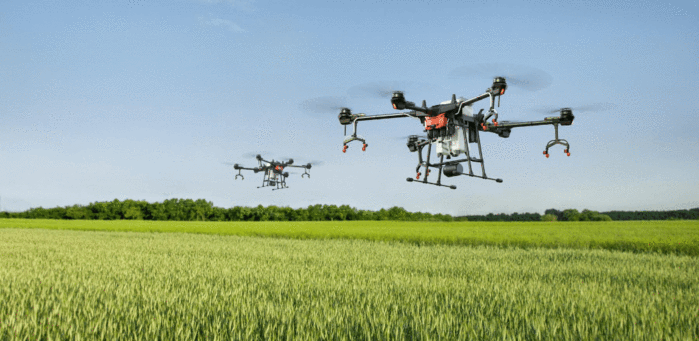
For greater efficiency, the Agras series can be used for swarming. Up to five Agras T16 drones can be controlled by a single T16 remote control, while one Agras MG-1P controller can control up to five MG-1P aircraft simultaneously, doubling the efficiency of single pilot operations.
Crop spraying drones v Manual methods
Using drones for crop spraying is a much more efficient and cost-effective process than manual methods.
This table provides a breakdown of the real-world benefits of deploying a DJI Agras drone over traditional methods, in terms of efficiency, safety and control. This example is based on the DJI Agras T16 but provides a snapshot of the overall benefits when deploying any Agras series drone.
MANUAL |
DJI AGRAS T16 |
|
|---|---|---|
Efficiency |
3-4 hectares per day |
60 hectares per day |
Standardization of work |
Manual planning |
Coordinated with the positioning system to perform route planning and improve work efficiency. |
Pesticide type |
Common pesticides |
Support aviation special chemicals, high utilization rate, can save more than 20% pesticide. |
Control effect |
It is easy to lose or re-spray and with low pesticide penetration. Due to the low efficiency of the work, it is difficult to carry out a protection of large areas in a short period of time, which is not suitable for unified control. |
The pesticide is sprayed evenly and has good penetration due to the downward wind flow from the aircraft. It can perform large area operations in a short period of time. |
| Safety | Workers are very close to pesticides, which pose a serious health risk. | The worker is separated from the pesticide and does not need to access hard-to-reach areas. |
CROPS INSPECTION DRONES
Save money and identify problems through aerial data.
Information that cannot be seen with the naked eye
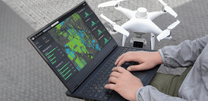
Crop inspection is a vital part of agriculture and a drone can be used to acquire quick, accurate and meaningful information.
Drones can carry a combination of zoom, thermal, multispectral, NDVI and visual cameras to draw precise data that cannot be seen with the naked eye or is difficult to collect from ground level.
This provides vital, real-time information on crop growth, differences between healthy and distressed plants, and weed control, thus enabling agriculture professionals to identify problems quickly, precisely and accurately and better target their field research.
Drones can be used to perform these surveys as often as the job requires. This accurate and repeatable multi-year drone data allows for better planning and monitoring of improvements, such as ditches and evolving fertilizer applications.
As an added benefit, this meaningful data can be processed instantly and can be quickly shared with key staff and decision makers to help maximize agricultural results.
“Efficient weed control in an agricultural operation is key. Knowing when and where to apply the herbicide can provide significant savings, not only in preventing crop damage, but also in minimizing the amount of product that is purchased and applied. Remote sensing technology can help growers evaluate the effectiveness of treatments, identify problem areas and implement necessary corrective actions ”.
MicaSense and Dynamic Wings
The best drones for crop inspection
As the world's leading drone manufacturer, DJI has a number of solutions to help farmers gather vital information on crop health and vegetation management.
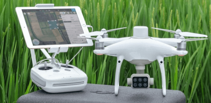
The Phantom 4 Multispectral is a precision agriculture dedicated drone, which allows agriculture professionals to acquire plant-level data.
The drone is equipped with an integrated imaging system that includes 1 RGB camera and a multispectral camera with five sensors covering the blue, green, red, red and near infrared bands.
Users can switch between NDVI images and live RGB feeds to highlight areas of attention and enable targeted treatment decisions.
The Phantom 4 Multispectral benefits from RTK accuracy, while the DJI TimeSync system allows you to obtain accurate positioning data on the images captured by the cameras.
This allows farmers to make timely and informed decisions about crop treatment and health, reducing costs, saving on resources and helping to maximize yields.
The DJI Matrice M300 RTK is another reliable option for farmers. While not strictly an agricultural drone, the M300 RTK can be integrated with several payloads to capture key agricultural information, including the H20T camera which boasts thermal and zoom capabilities. Thermography has a wide range of applications in agriculture, such as irrigation scheduling, plant disease detection and fruit yield estimation, while a zoom camera can be used to focus on specific areas.
The DJI Matrice 300 RTK can also be integrated with third-party payloads, allowing farmers to pair the drone with dedicated and specialized NDVI and multispectral sensors.
Meanwhile, the DJI Mavic 2 Enterprise series offers a lightweight, foldable and portable option for farmers. The standard Mavic 2 Enterprise comes with a dynamic zoom camera, while the Mavic 2 Enterprise Dual comes with thermal capabilities. Both drones can carry modular accessories, such as a speaker, spotlight, and beacon, to add versatility to farming missions.
DJI Phantom 4 Multispectral
- 5-Camera Array covering Blue, Green, Red, Red Edge and NIR (Near Infrared), plus an RGB sensor
- Integrated Spectral Sunlight Sensor for Increased Accuracy
- Live RGB and NDVI Feed Available from the Drone
- Integrated RTK for 1-cm Accuracy
- 27 Minute Flight Time
- 7km Transmission Range
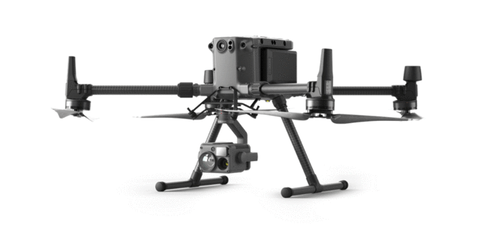
DJI M300 RTK
- Up to 55 minute flight time.
- IP45 weather-resistance rating.
- Carry up to three payloads at once.
- H20T camera, built for the M300 RTK, is a multi-sensor solution, including thermal and zoom.
- Integrate specialist third-party multispectral and NDVI sensors.
- Enhanced safety features and flight redundancy.
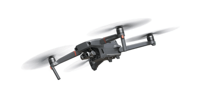
DJI Mavic 2 Enterprise Series
- Mavic 2 Enterprise has a 12MP camera with 2x optical and 3x digital zoom capabilities.
- Mavic 2 Enterprise Dual has thermal and standard RGB sensors.
- Lightweight, foldable, easily transportable, and quick to deploy.
- 24GB onboard storage
- Omnidirectional object sensing
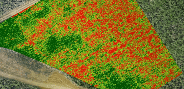
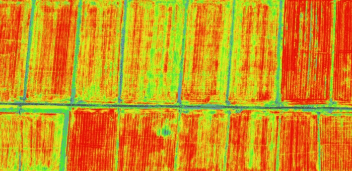
Multispectral camera sensors are playing a vital role in agriculture, especially when integrated with a drone.
This imaging technology uses a range of wavebands - including red, red border, and near infrared - to highlight a wide range of meaningful agricultural insights, which in turn lead to smarter and more informed farming.
In general, multispectral sensors collect light from various wavelengths that the human eye cannot distinguish. These images help farmers learn more about soil productivity, plant health, crop estimation and irrigation management, among other things.
Among the many benefits of multispectral imaging, farmers can learn about the Normalized Difference Vegetation Index (NDVI); the green index of plants and the classic indicator of plant health. NDVI data allows agriculture professionals to learn more about canopy cover, pest outbreaks, soil moisture and how to optimize crop rotation.
Farmers can also collect data from multispectral vegetation bands for a variety of insights. These bands include:
- Green : Refers to energy reflected in the 500-600nm spectral band and helps detect chlorophyll levels.
- Red : the energy reflected in the spectral band of 600-700 nm. For crops, this gives excellent contrast between plants and soil.
- Red-Limit : A very narrow band (700-730 nm) at the near-infrared entry point. This band is sensitive to plant discomfort and provides chlorophyll information, which is useful for crop health analysis and plant counting.
- NIR (Near-Infrared) : Wavelengths in the range 700 nm - 1.3 µm. It offers strong reflectance and is used to show chlorophyll levels. NIR can be used to monitor changes in crop health and productivity.
As multispectral imaging plays an important role in agriculture, there are numerous drone solutions on the market to enable this data collection.
The DJI Phantom 4 Multispectral is an all-in-one solution, ready to use, with the ability to acquire RGB and multispectral data covering the blue, green, red, red border and near infrared bands.
Other leading solutions include MicaSense's RedEdge-MX dual-camera imaging system, which provides 10 bands for advanced remote sensing and agricultural research. It can be integrated with DJI drones, such as the Inspire 2 and UAS of the Matrice 200 series.
Meanwhile, SlantRange's 4P and 4P + sensors enable accurate data collection across six spectral bands and can be integrated with DJI DRONES via DJI's Payload SDK.
AGRICULTURAL MAPPING DRONES
Key insights - Quickly.
Digitize your field
Drone mapping is becoming a key tool for farmers.
Digitizing your field helps maximize operational efficiency and monitor agricultural production, plant breeding, irrigation and animal damage.
Drone mapping provides better information on crops from above, serving as the basis for ground work.
Turn images into in-depth maps that can aid in decision making and can be shared quickly.
Drone mapping also offers the ability to set predetermined flight paths for autonomous missions and repeatable and accurate data collection.
Drone mapping can provide the following information:
- Field Inspection : Identify problems with high-resolution, quick-create maps.
- Irrigation : Manage irrigation and minimize soil erosion by creating a digital surface model. This helps farmers understand irrigation variability and highlight areas at risk of erosion.
- Field Interpretation : Analyze different vegetation index maps to identify key cultivation areas that need to be addressed and ensure the sustainability of new techniques.
- Focused Analysis : Generate comprehensive zone maps to identify how to achieve higher yields.
- Insurance Claims : Create maps to validate and support insurance claims by capturing crop damage footprints.
- Historical Analysis : Compare side-by-side maps to track the progress of a crop over time. This allows you to dig deeper into problem areas, take a closer look at the patterns, and visualize how to crop
the emergence and health of the plants took place throughout the entire growing season.
“We are able to create variable speed maps to spray only certain sections of the field. We can scan a field with a drone in a matter of 30 minutes and have a complete map that maps the health index of the entire area. The drone provides really detailed information. "
Bowles Farming Co - The Value of Drones in Agriculture, DroneDeploy
The best drones for farm mapping
The DJI Phantom 4 RTK is an ideal drone for agricultural mapping.
The Phantom 4 RTK performs aerial mapping 100 times faster than manual operations, helping to scan and map target areas to identify all aspects of a field.
The benefits of the DJI Phantom 4 RTK include:
- Capture quality image data with the one-inch 20MP CMOS sensor. The mechanical shutter makes mapping missions or regular data capture seamless, taking photos without the risk of shutter blurring.
- Get survey-grade results more efficiently.
- The RTK module provides centimeter-level positioning data in real time for improved absolute accuracy of image metadata.
- The TimeSync system continuously aligns the flight controller, camera and RTK module.
- Compatible with DJI Terra and other drone mapping software.
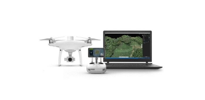
Transform your drone data
Drone farm mapping software is an important part of using UAS for agriculture, turning collected data into meaningful information.
Drone mapping software can also be used to simplify the process of deploying a drone, creating pre-mission flight paths for greater efficiency and automated flights.
There are numerous software solutions on the market for mapping farms with drones. Here are some of them:
DJI Terra
DJI's drone mapping and 3D modeling software package can be used to great effect for agriculture.
- Add waypoints to draw a polygon as target areas and flexibly adjust flight parameters as you wish, plan a mission and set desired flight parameters to suit your needs.
- DJI Terra collects images of the target areas and merges them into maps that can be used in real time.
- Simplified Workflow: Marking of boundaries, obstacles and calibration points is done on the DJI Terra interface.
- Process multispectral images to generate vegetation index maps including NDVI and NDRE. Create prescription maps for variable rate application using DJI's Agras drones to improve yields and reduce costs.
Pix4D
Pix4Dfields is advanced agriculture mapping software for aerial crop analysis and digital agriculture.
- Create maps quickly (no internet connection required) to make decisions and act faster, without leaving the field.
- Eliminate the guesswork by generating accurate orthomosaics, digital surface models, index maps, zones and accurate prescription maps.
- Use the Pix4Dcapture app to easily plan and control your drone flight for optimal mapping.
- Share your maps with all project stakeholders for seamless collaboration using Pix4Dfields PDF report tool.
DroneDeploy
The DroneDeploy software package offers agriculture information to improve management decisions throughout the year.
- Intuitive software: Travel 160 acres in less than 15 minutes.
- Identify variability and gather information in the field with multispectral data processing.
- Gain real-time field insights with Live Map to generate variable rate prescriptions using crop health imagery throughout the season and support a more productive scouting program.
- Understand the performance threats before setting foot in your fields.
SMART FARMING WITH DJI
Leverage the DJI ecosystem for a complete agricultural solution.
From planning to operation: all with drones
DJI has launched a complete agricultural solution, from planning to operation, conducted entirely by drones and associated software.
This complete package makes farming practices more efficient by combining a range of drones, such as the DJI Agras series, the DJI Phantom 4 RTK and the DJI Phantom 4 Multispectral.
DJI Terra, a drone mapping software package, can also be used in this DJI agricultural ecosystem to produce agricultural maps from data collected by drones and generate targeted flight paths.
The information below shows how multiple DJI platforms can be brought together to provide an end-to-end precision farming package.
3D flight path planning
Navigating difficult terrain is now easier thanks to digitized farming methods.
The DJI Phantom 4 RTK can scan and map target areas to identify all aspects of a field, and DJI Terra can process this data to create maps and reconstructions for a variety of agricultural insights. This information can then be used to distribute the DJI Agras T16 in specific areas.
In Orchard mode, DJI Agras drones can identify each tree, generate 3D flight routes based on their shapes and conduct efficient spraying.
FIRST STEP
Data Acquisition - Phantom 4 RTK
Centimeter level positioning
High-precision data collection
Fast and efficient mapping
STEP TWO
Planning - DJI Terra
Real-time mapping
2D / 3D reconstructions
Flight paths generated by AI
STEP THREE
Operation - DJI Agras T16
Spray up to 10 hectares per hour
The spraying method is precise
Easily cover difficult terrain
Crop protection
The DJI ecosystem can be leveraged to provide a complete solution to monitor crop health and generate treatment procedures.
The Phantom 4 Multispectral can scan target areas and generate multispectral graphs that provide useful information on crop health and help formulate variable spraying and seeding maps.
Users can access DJI Terra shapefiles and apply them to spraying and seeding operations performed by Agras drones.
FIRST STEP
Data Acquisition - Phantom 4 Multispectral
Centimeter level positioning
Data collection through multispectral sensors
Collect 47 hectares of images in one flight
FIRST STEP
Data Acquisition - Phantom 4 Multispectral
Centimeter level positioning
Data collection through multispectral sensors
Collect 47 hectares of images in one flight
STEP TWO
Field planning - DJI Terra
Real-time NDVI mapping
Agricultural shapefiles
AI field planning
More efficient drones on steep terrain
DJI Agras drones are used for vineyard management.
Thanks to their automated operation and the ability to access hard-to-reach areas, these drones have made spraying vineyards an easy and visible workflow.
Remote Vision is a company that uses DJI Agras drones for vineyard management, piloting the MG-1P and T16 in Switzerland.
Charged with disease prevention, Agras drones are filled with a range of chemicals to protect vines from the spread of powdery mildew and other fungal diseases.
Agras drones can spray 100 liters per hectare and are capable of targeting steep hills that are difficult to reach using a tractor.
Ueli Sager, of Remote Vision, said: “The customer compared the spraying of the drones with the spraying of the previous tractors. The customer is satisfied with the drone spraying for a variety of reasons, including no personal contact with pesticides, absence of phytotoxicity and DJI Agras is much more efficient on steep terrain. "
Effective drones for monitoring test batch sites
Drone AG used the DJI Mavic 2 drone, along with the Pix4Dfields, DroneDeploy and Skippy Scout drone software packages, to conduct grain tracking.
Jack Wrangham, of Drone AG, said: “Drones can be very effective for monitoring test sites. This is because they can fly low over the crop, achieving a high level of detail. Satellite imagery simply doesn't have a high enough resolution to see individual textures. "
DroneAG used the drone to collect ultra-high resolution images of the textures. The team mapped the plots and flew over the sites at four key times during the season to identify early settlement, subsequent crop progress and possible disease detection.
This regular and accurate data acquisition enabled DroneAG to identify progress and problems and collect accurate comparisons.
DroneAG used its Skippy Scout software to automate drone flights to capture near-crop images in leaf-level detail. This is useful for test plots, to see what is happening to individual plants.
The drone helped increase profits
Nutrien used DJI drones and SlantRange solutions to enhance a customer's strawberry season.
The main goal was to evaluate the crop for nutritional solutions, addressing crop problems as early as possible and helping the grower achieve the best possible yield.
During the process, Nutrien found that a drone was useful in a number of aspects, including accuracy and speed. Individual leaves on the plants became visible using the drone solution, helping to identify pest problems and leading to quick preventive measures, while the ability to view data in the field, minutes after the flight, was a huge plus.
By the end of the season, profits had been increased and yields improved.
Drones allow for precise mapping
Rogers Family Coffee Co. uses drones to create new management methods at their research farm in Kona, Hawaii.
Using DJI drones integrated with MicaSense sensors, the company uses vegetation indices to allow them to track nutrient inputs, identify pest infestations, and visualize mountainous terrain.
Andros Bracamontes, research and development specialist for Rogers Family Co, said: “Drones allow us to accurately map the entire farm on a regular basis and we are now aligning the images with our management strategy. We used to have to hike to monitor fields, which can be a big challenge in the steep slopes of some of our farms, now we can monitor by air in a fraction of the time and at a single plant level. "
DRONES AGAINST SATELLITES FOR AGRICULTURE
What is the best method for agriculture?
Which eye in the sky should you use?
Drones are more efficient and effective for agriculture than manual methods. But how do they compare with satellites?
In truth, they both have their advantages and they boil down to the specific application.
However, there are some times when drones have the edge.
Take cloud cover, for example. Satellite imagery can be severely affected by cloud cover, limiting what can be seen. A drone, on the other hand, can fly closer to the earth, under cloud cover, to get the data you need.
There is also the problem of satellites flying around the earth within a certain time. If you want immediate data capture, it may be best to deploy a drone.
Because drones can fly closer to the ground, they can collect highly accurate data, take photos to distinguish a weed or crop, or showcase each particular plant. Due to its distance from the earth, a satellite cannot capture that level of detail.
However, if high accuracy is not a priority, satellites can have the advantage, especially over large farms where they can cover a larger area.
Thanks to their wide reach, the collected image is complete, eliminating the need to embroider the image. Conversely, as drone shots capture smaller areas, image stitching is required after drone flights.
Another advantage of using satellites is that their records go further back. Thanks to this archival data, you can travel through time and create a longer image of your farm.
But, while the drone versus satellites issue holds true, it doesn't always have to be a choice between the two. Rather, using them together can be extremely helpful, by pinpointing an initial problem via a satellite and then deploying a drone to refine the problem and address it accurately and quickly.
FREQUENT QUESTIONS
Agricultural drones: your questions with answers
Drones are helping to revolutionize agriculture by providing farmers with fast, accurate and repeatable data collection, which in turn provides vital information and helps guide decision making.
This depends on your needs. But DJI has a range of UAS in its agricultural ecosystem, such as Agras crop spraying drones; P4 multispectral drone for crop monitoring; and the Phantom 4 RTK farm mapping drone.
If you are flying your drone for commercial reasons, then yes, you will need to take a drone training course. From the end of December 2020 in Europe, the training requirements will change; determined more by the size of your drone, rather than being defined by commercial or non-commercial operations. For more information on drone training, consult the relevant section of our website.
In the United States, commercially flying drone operators will have to pass the FAA Part 107 test.
If you are in Europe, then yes, your drone will need to be registered if it exceeds 250 grams.
If you are in the US, your drone will need to be registered if it exceeds 0.55lbs.