

Guide to digital terrain models, digital elevation models and digital surface models for surveying with drones: what they are, their differences, applications and how they can help LiDAR and photogrammetry with drones.
If you are using a drone for surveying, chances are you will come across the terms Digital Terrain Model, Digital Elevation Model, and Digital Surface Model.
But what exactly are they, what are the differences and how can they help?
Read on to find out.
Digital elevation models
Digital elevation models, also known as DEMs, are a visual representation of the elevation data for each point acquired on your site.
Instead of representing the actual appearance of your site in person, DEMs generally use color to indicate elevation differences, as this image shows.
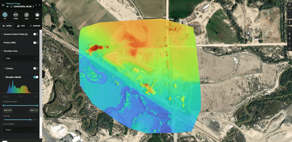
DEMs are raster datasets or grids showing the highest vertical point (z) recorded for each horizontal coordinate (x, y).
The smaller the cells in the grid, the more detailed the information is within a DEM data file. So, if you're looking to model with lots of detail, then a little grid spacing (or small cell size) is the way to go.
When viewed, these raster files represent the shape of your site's terrain, which can be used as a reference for the topography you are working on.
Digital surface models and digital terrain models
Digital Elevation Models (DEM) are a superset of Digital Terrain Models (DTM) and Digital Surface Models (DSM).
So what's the difference between a DTM and a DSM?
- DTM : a bare surface model. In other words, characterizing exclusively the terrain and the terrain.
- DSM : The most general form of surface model that includes all acquired points, representing natural and man-made features. A DSM includes the tops of buildings, trees, power lines, and other objects. Essentially, it's a canopy model and only sees the ground when nothing else is above it.
The chart below is a simple diagram showing the differences between a DTM and a DSM. Notice how the DTM (orange line) follows the ground, while the DSM (green line) follows the structures on the surface, i.e. the top of the house and the tree.
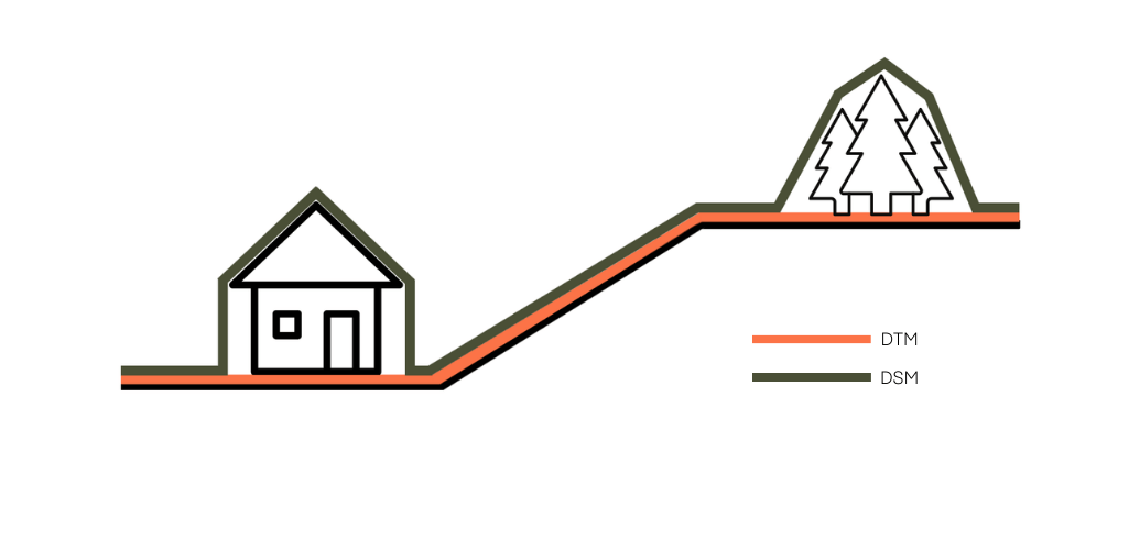
So how does this relate to a real-life dataset? The following example demonstrates this, with the DTM on the left and the identical DSM on the right.

Again, note how the DSM shows the tops of houses and greenery; features that are not present in the bare-earth DTM.
How can drones help to generate DEM, DSM and DTM?
Drones are an inexpensive, fast and effective data collection tool for generating DEM, DSM and DTM.
Technological advances in recent years have led to the development of drones capable of conducting photogrammetry and LiDAR missions.
Both of these applications are fundamental for creating DEM, DSM and DTM. Our LiDAR vs Photogrammetry guide presents an in-depth comparison between the two, but in a nutshell:
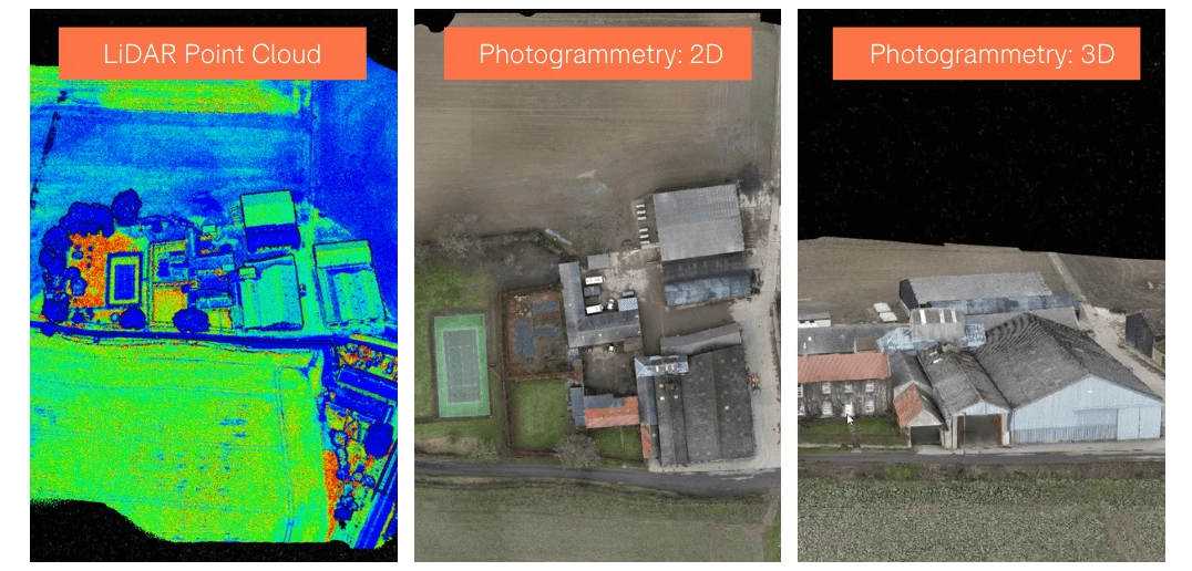
- LiDAR : An acronym for light detection and distance, LiDAR works by sending pulses of light to the earth's surface or a feature on it and measuring the time it takes to reflect. This provides an accurate positioning point of where on the Earth's surface the laser hit and this data can be used to build a 3D point cloud representing the terrain, topography and features of the scanned area.
- Photogrammetry - the art of capturing high-resolution photographs to recreate a prominent area. These images are processed and merged using sophisticated software to create realistic, georeferenced and measurable 3D models of the real world.
As highlighted above, there are clear differences between LiDAR and photogrammetry.
Therefore, careful consideration is required before implementing these drone mapping techniques for DTM, DSM and DEM generation.
LiDAR, for example, is particularly effective for DTM data acquisition, compared to photogrammetry, especially in high vegetation areas.
How come? Because by its very nature, LiDAR can penetrate the spaces between leaves and branches to reach ground level, thus obtaining more accurate soil data.
Conversely, vegetation can prevent drone photogrammetry from acquiring an accurate representation of what soil topography looks like - essentially, it will only capture features that protrude from the earth's surface.
This excellent graph below - created by Ben Bishop, Technical Director of Flythru Limited - shows the difference between LiDAR and photogrammetry for the DTM generation.
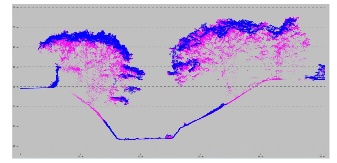
In this example, the LiDAR data is pink and the photogrammetry is blue. Note how photogrammetry does a great job of capturing tree tops, but it can't compete with LiDAR when it comes to gaining ground information in areas obscured by vegetation.
Because of this, photogrammetry becomes more effective for DSMs.
Remember, DSMs represent both natural features and those built on the earth's surface, such as canopy of trees and changes in vegetation.
Therefore, the high resolution images collected during a photogrammetry mission are useful for building this type of maps. But LiDAR can also be used for DSMs too.
The best drones for DEM, DSM and DTM
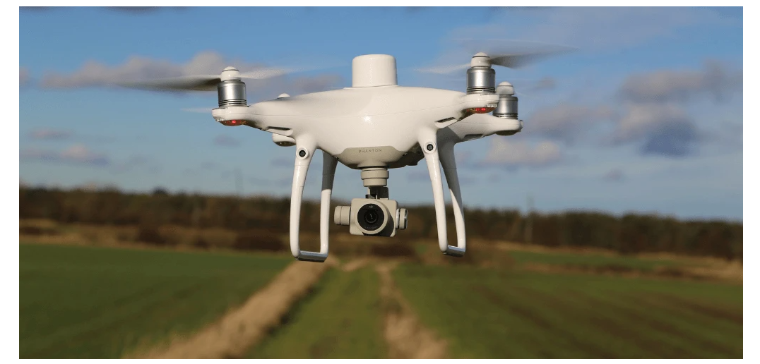
DJI has designed a number of drones for aerial survey missions, most notably the M300 RTK and the Phantom 4 RTK.
Among them, the M300 RTK is best suited to creating these models as it can be integrated with photogrammetry and LiDAR cameras.
The DJI Zenmuse P1 (below, left) is a dedicated photogrammetric camera with a 45MP full frame sensor, while the DJI Zenmuse L1 (below, right) is a LiDAR sensor with photogrammetry capabilities.
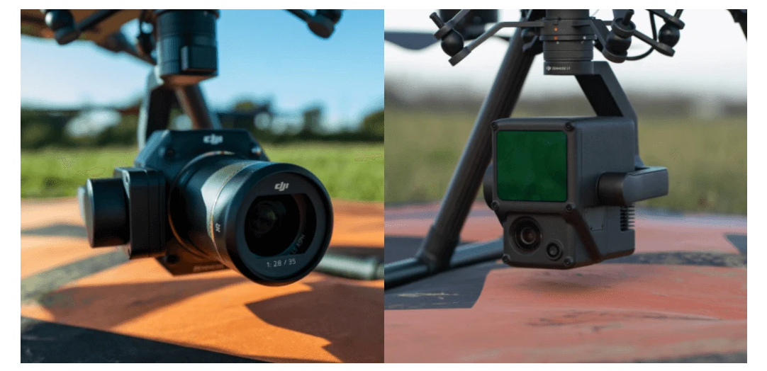
The M300 RTK coupled with the P1 or L1 makes aerial survey highly accessible, especially in the case of LiDAR data acquisition. And, thanks to a combination of the drone's increased strength and individual camera specifications, this pairing presents an incredibly efficient mapping solution, covering large areas in short spans of time.
Meanwhile, the Phantom 4 RTK It is a compact, low-altitude drone detection solution, but has a fixed 20MP photogrammetric camera. Therefore, while it is an effective drone detection tool, it lacks the versatility of the M300 RTK as it cannot be integrated with LiDAR.
DEM, DSM and DTM - Types of applications
DEMs - incorporating DSM and DTM - are critical in areas such as infrastructure management, hydrology managing coastal erosion, archeology, flow direction studies, land use and urban planning and subsequent landslides.
Drones, DEM, DSM and DTM - Summary
Drone sensing has become a major industry application and DEM, DSM and DTM can form an important part of mapping projects.
Unmanned aircraft facilitate the collection of the necessary data for these types of models.
The choice between DEM, DSM and DTM depends on the type of information required, while the choice between photogrammetry and LiDAR is also a key consideration.
But like all outbound data associated with drone detection, these digitized assets provide in-depth insights into your job site that can drive decision making and ROI.