

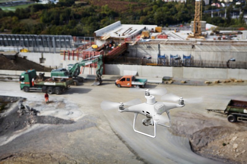
STRABAG employs the DJI Phantom 4 RTK for building survey to create precise 3D models
The European motorway network extends for 80,000 km and crosses several countries. In 2017, Germany ranked second in Europe and around the world with 12,996 km of motorways, making Germany a major transit country for millions of cars and trucks heading to destinations in Eastern or Southern Europe, creating severe stress for existing structures.
The German Federal Ministry of Transport conducted a comprehensive analysis of the projected increase in traffic from 2010 to 2030, calculating an increase in the number of passenger-kilometers by 12% and in tonne-kilometers by 38%. Concluding the need for renewal and extension of the German transport network, the ministry recommended a public investment of 270 billion euros by 2030 in its federal transport infrastructure plan. Almost 75% of the investment is intended to cover the renewal and extension of the federal highways and roads.
To meet the growing demand for improved transportation infrastructure, the teams sought out new technologies to increase efficiency. During this process, many contractors have employed drones on site to create regular site maps and conduct survey missions more quickly.
STRABAG - Specialists in the construction of road works
Executing the ministry's plan is a challenging undertaking that requires long-term planning and coordination from business and private sector specialists to complete these large-scale road construction projects.
STRABAG SE, the sixth largest construction group in Europe, and its German subsidiary STRABAG AG are the main players in the construction of transport infrastructure, accounting for 37% of STRABAG's production volume. With over 100 years of experience and over 70,000 employees worldwide, STRABAG has deserved its leading position in the market for good reason. It has an advantage over technological innovation.
STRABAG teams work in parallel on 9,100 construction projects across Europe, with 4,900 of them in Germany. Together, these projects add up to 600km of highways under construction or renovation, which require efficient workflows and communications to keep these projects on time and on budget. Therefore, precise land planning plays a crucial role in the management and quality assurance of construction projects.
The Digital Survey business unit and STRABAG UAVs have deployed drones for internal and external customers to map projects saving time and costs since 2015. As this technology has been implemented for an increasing number of customers, new applications have arisen that require high accuracy. To meet these precision needs, STRABAG has added the new Phantom 4 RTK to the tools of the inspectors.
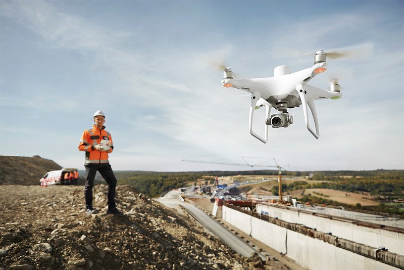
The construction of Germany's A3 motorway near the city of Würzburg is one of STRABAG's current long-term projects. Starting in 2014, which is expected to be completed in 2021, STRABAG is extending the highway from two to three lanes, building a new soundproofing tunnel and replacing a deteriorated bridge, and more. These improvements are implemented over several kilometers of the motorway, on complex terrain with steep slopes and numerous hairpin bends. With a large-scale project like Würzburg taking many years, efficient site surveying is a priority for the STRABAG team, enabling them to accurately plan and track progress.
“Using drones for building mapping has many advantages. Their integration changes our workflow and simplifies many operational steps. Conventional surveying methods also provide 3D models, but digital terrain models created from drone data provide a higher point density, so reality is described in much more detail, "says Thomas Gröninger, Head of the Digital Object Survey of the Business Unit and UAV.
DJI Phantom 4 RTK - A game changer for building survey
Today in STRABAG drones are a common tool for some aspects of building mapping. Drones have proven to be superior to previous traditional surveying methods in certain environments, such as projects with sparse vegetation, availability of GPS and significant sunlight. However, achieving accurate detection results (i.e. up to 3cm accuracy) with a non-RTK / PPK drone requires the placement of up to 40 Ground Control Points (GCPs) per square kilometer, which would take several hours.
The new DJI Phantom 4 RTK it features an integrated centimeter navigation and positioning system and a high performance imaging system that supports both RTK and PPK solutions. To provide images for exceptional relief results, the Phantom 4 RTK records factory-calibrated lens parameters along with location, altitude, and other data on each photo, matching the positioning data to the center of the camera's CMOS sensor using the new TimeSync system. Using the RTK positioning module (GPS L1 L2, GLONASS L1 L2, Galileo E1 E5a and BeiDou B1 B2) the Phantom 4 RTK potentially reduces the required amount of GCP to 0. For quality management purposes 3-5 GCPs per square kilometer are widely accepted in the industry. When using the Phantom 4 RTK with fewer GCPs, surveyors can achieve a slight increase in accuracy and save at least 75% of GCP setup time.
To take full advantage of the fully integrated system, RTK mode surveyors use RTK network services. For even more accurate results, especially in areas with poor mobile network coverage, the D-RTK 2 high-precision GNSS Mobile Station can easily be connected.
Built for Surveyors
To explain in depth the inner workings of the DJI Phantom 4 RTK , the drone acquires the original satellite observation data as well as the ephemeris data and stores them in a PPKRAW.bin file in RTCM 3.2 format. Furthermore, the Phantom 4 RTK converts satellite data on the fly into Receiver Independent Format (RINEX) and writes the data to a RINEX.obs file. Thanks to the internal synchronization of the GNSS position and the camera, the Timestamp.MRK file provides an extremely accurate recording of the image position. All data relevant to the operation is stored on a Micro-SD card in a single folder for each mission. The consistency of the data of the Phantom 4 RTK reduced the time required to validate data and results in an efficient post-processing workflow with little or no manual adjustments.
Without GCP, the achievable horizontal accuracy is up to 3cm and the vertical accuracy up to 5cm within the WGS84 global reference network used by the Phantom 4 RTK . In areas with no mobile network coverage, the Phantom 4 RTK allows surveyors to use PPK for subsequent evaluation while maintaining the same accuracy provided by RTK.
“When setting the flight path, you need to select the altitude and overlap. The P4R offers an integrated flight planning app in the remote control, including all relevant detection parameters to make flight planning easy and efficient, ”says Philipp Mielke, Business Object Digital Survey Teamleader and UAV at STRABAG.
The Phantom 4 RTK has been designed to make drone mapping easy, convenient and efficient with the ability to fly for up to 30 minutes, allowing users to map a large area in one flight. Even if the area is too large to map on a single battery charge, the GS RTK app's resume function automatically resumes the mission after the battery is replaced. Phantom 4 RTK it also saves more time by flying longer and faster. The ability to fly at a consistent height over complex terrain and specific corridor mapping features are big improvements for surveyors. DJI Mobile SDK enables these features.
Data processing
The captured data can be easily integrated into third-party photogrammetry software, offering point clouds and industry-acceptable 3D models. Philipp Mielke points out that “solutions to upload drone data from a laptop on site to the cloud for processing are another step in making on-site surveying innovative. It makes surveyors independent of the geographical distances between the construction site and their office to allow immediate and powerful data processing. “Viewing the 3D model in the cloud shortly after the data has been acquired allows the engineers on site to review the construction work and initialize the next steps.
Thanks to the highly detailed and comprehensive survey data, surveyors and CAD technicians can be sure they are collecting all data at once without having to go back to the construction site to gather more information, thus saving time. After processing the 3D point clouds from the photos captured by the drones, the data is post-processed according to the individual project requirements. Typical initial workflows include point cloud classification to filter out unwanted objects such as vegetation, vehicles and man-made objects, vectorization and feature extraction. The processed data is then used for digital terrain and surface modeling, mass and volume calculations, and Building Information Modeling (BIM).
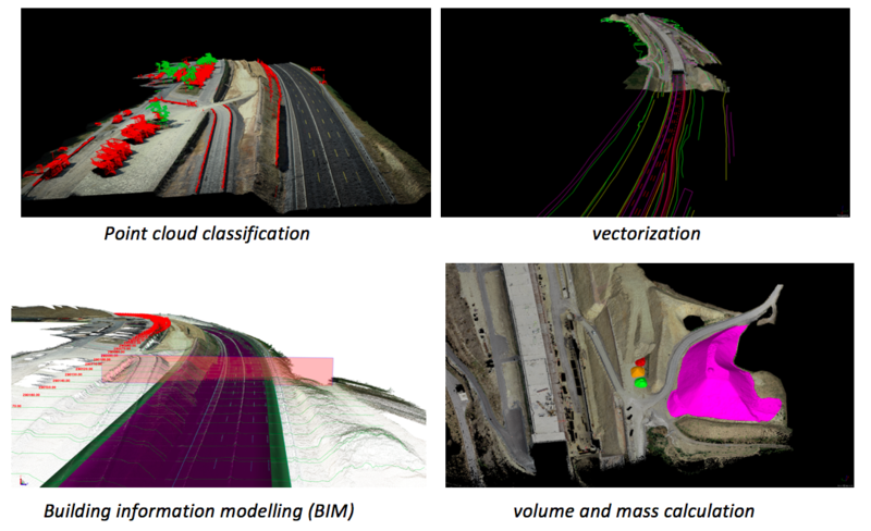
In addition to 3D results, 2D orthophotos can be created with third party software to provide excellent overviews of large construction sites from a bird's eye view. Both 2D and 3D data are also a good basis for starting pioneering projects, driving regular coordination and reviews.
Drones - Digitization of the construction sector
The 3D models generated by the drone offer a variety of analysis and evaluation options. Depending on the accuracy required, the most common use cases are monitoring, inspection, documentation and construction progress monitoring. All of the above is done with drones in the Würzburg shipyard.
“STRABAG seeks to expand the use of drones for construction projects globally. We currently employ 170 surveyors in Germany and 300 across Europe. The new DJI Phantom 4 RTK is an easy to use and versatile drone with built-in RTK networking capabilities. This combination will allow STRABAG to equip multiple drone teams to make construction survey workflows faster and more efficient, ”summarizes Thomas Gröninger. “ DJI Phantom 4 RTK it is an essential addition to the surveyor's toolbox and will play an important role in the digitization process of the construction industry ”.