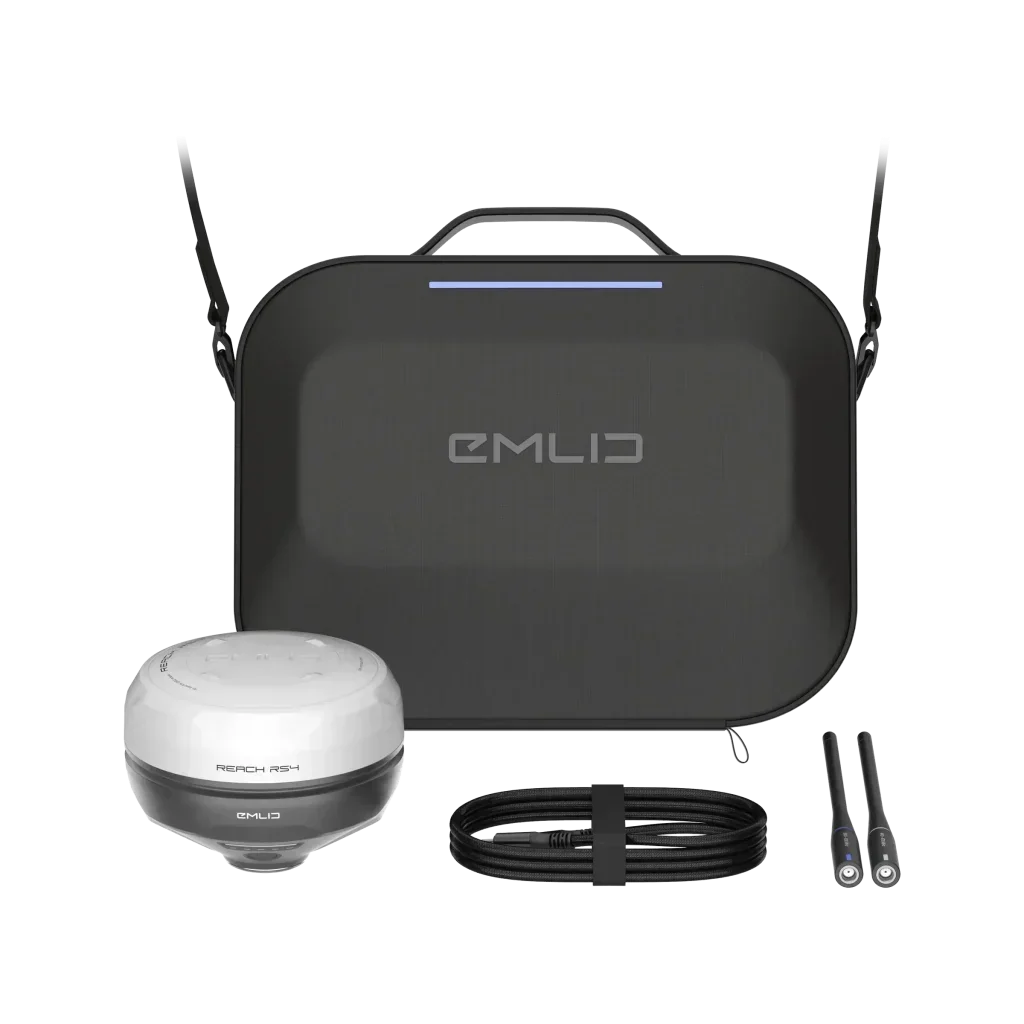
EMLID REACH RS4
EMLID REACH RS4
Impossible de charger la disponibilité du service de retrait


L'Emlid Reach RS4 est un récepteur GNSS RTK multifréquence de nouvelle génération conçu pour les relevés topographiques, le SIG et l'agriculture de précision, offrant une précision centimétrique même sous un couvert forestier dense et dans des environnements difficiles. Grâce à son antenne haute performance, au système TILT avec IMU intégrée et à la connectivité radio, LTE et NTRIP, il permet des opérations rapides, fiables et hautement productives sur le terrain.
Présentation du produit
Le Reach RS4 est un récepteur GNSS RTK toutes bandes capable de suivre toutes les principales constellations (GPS, GLONASS, Galileo, BeiDou, QZSS, NavIC) sur les bandes L1, L2, L5 et L6, avec 672 canaux dédiés. L'unité est conçue pour fournir un FIX en moins de 5 secondes, tout en maintenant la solution même en présence de trajets multiples, de végétation ou de scénarios urbains complexes.
La compensation de l'inclinaison basée sur une IMU de nouvelle génération permet de mesurer des points avec une canne inclinée sans perte de précision opérationnelle, ce qui réduit les temps de stationnement et facilite les relevés dans des endroits difficiles. Le boîtier en alliage de magnésium avec protection IP68 garantit robustesse et résistance aux chocs, à l'eau et à la poussière, rendant le RS4 adapté aux chantiers, aux environnements agricoles et aux conditions météorologiques extrêmes.
Utilisation et applications
Le Reach RS4 est idéal comme rover RTK connecté via NTRIP ou comme paire base/rover via radio UHF/LoRa intégrée, couvrant ainsi aussi bien les relevés mobiles que les stations de référence locales. Il est utilisé pour les relevés topographiques, les implantations sur chantier, les relevés SIG de haute précision, l'agriculture de précision et les projets d'infrastructure où des données fiables et reproductibles sont nécessaires.
L'intégration avec Emlid Flow et avec les principales applications SIG et de chantier permet des flux de travail fluides pour la gestion des points, des lignes et des surfaces, ainsi que l'exportation vers des formats standard de l'industrie. La combinaison de la connectivité multiple, de l'autonomie étendue et du TILT avancé rend le RS4 particulièrement adapté aux équipes de relevé exigeant une productivité élevée avec des configurations rapides.
Spécifications techniques principales
GNSS et performances
- GPS : L1C/A, L2C, L5.
- GLONASS : L1OF, L2OF.
- Galileo : E1‑B/C, E5a, E6.
- BeiDou : B1I, B1C, B2a, B3I.
- QZSS : L1C/A, L1C, L2C, L5.
- NavIC : L1‑SPS, L5‑SPS.
- Nombre de canaux : 672.
- Temps de FIX : typiquement < 5 s en mode RTK.
- Fréquence de mise à jour : jusqu'à 10 Hz.
TILT et capteurs
- Compensation de l'inclinaison : basée sur une IMU intégrée de nouvelle génération, optimisée pour une initialisation rapide et une utilisation intuitive.
- Utilisation avec canne inclinée, permettant le relevé de points difficilement accessibles tout en maintenant une précision RTK.
Mécanique et robustesse
- Dimensions : 128,6 × 128,6 × 99,3 mm.
- Poids : environ 920 g.
- Corps : alliage de magnésium avec pare-chocs de protection remplaçables.
- Degré de protection : IP68 (résistant à la poussière et à l'immersion dans l'eau).
- Températures de fonctionnement : d'environ −40 à +65 °C, adapté aux climats extrêmes.
- Support à attache rapide : fixation rapide pour canne avec filetage standard 5/8″, conçu pour une fixation sécurisée même avec une canne inclinée.
Alimentation et autonomie
- Autonomie : jusqu'à 16 heures de travail continu en tant que rover RTK avec TILT actif.
- Batterie interne haute capacité (environ 7000 mAh) avec recharge via USB Type‑C.
- Support de recharge USB‑C avec alimentateurs et batteries externes compatibles.
Connectivité des données
- Radio LoRa :
- Puissance : jusqu'à 1 W.
- Bande : 868/915 MHz (compatible avec l'antenne 860–930 MHz incluse).
- Portée : jusqu'à environ 8 km dans des conditions optimales.
- Radio UHF :
- Puissance : jusqu'à 2 W.
- Bande : 410–470 MHz (compatible avec l'antenne incluse).
- Support de protocoles professionnels tels que TRIMTALK 450S pour l'utilisation avec des bases radio dédiées.
- Corrections RTK : support NTRIP avec formats RTCM3.
- Sortie de position : NMEA, LLH/XYZ, avec journalisation (logging) en RINEX, NMEA, LLH/XYZ, UBX sur mémoire interne.
- Mémoire interne : 16 Go pour l'enregistrement de sessions statiques et cinématiques.
- Interfaces :
- Bluetooth (version 4.2 ou supérieure, selon les révisions du produit).
- Wi‑Fi double bande pour connexion aux réseaux locaux ou points d'accès.
- USB Type‑C pour l'alimentation et le transfert de données.
Tableau des spécifications techniques de l'Emlid Reach RS4
Contenu de l'emballage
Le kit Emlid Reach RS4 est fourni complet avec tout le nécessaire pour commencer à travailler sur le terrain avec une configuration rapide et sécurisée. Les accessoires inclus sont sélectionnés pour exploiter à la fois la radio LoRa et la radio UHF intégrées, en plus de garantir un transport et une recharge aisés.
Sont inclus dans l'emballage
- Récepteur GNSS Emlid Reach RS4.
- Mallette de transport, conçue pour protéger le récepteur et les accessoires pendant les déplacements.
- Câble USB Type‑C pour la recharge et le transfert de données.
- Antenne LoRa 860–930 MHz pour une utilisation avec la radio LoRa intégrée.
- Antenne UHF 410–470 MHz pour la radio UHF intégrée.
Cette configuration permet d'utiliser le Reach RS4 à la fois comme rover NTRIP et comme élément d'une solution base/rover radio, en l'intégrant facilement dans les flux de travail topographiques et SIG existants.
Service de correction NRTK inclus (optionnel)
Avec l'option TruePoint CM (1 AN) vous obtenez la précision centimétrique maximale garantie sur toutes les constellations (Full GNSS). Un service de correction NRTK illimité pendant 12 mois, idéal pour travailler immédiatement sans interruption et avec une fiabilité maximale.
Expédition et Garantie
Expédition et Garantie
Tous les produits disponibles en stock seront livrés dans un délai moyen de 24/48 heures.
Garantie Italie avec support de conseil dédié, contactez-nous !