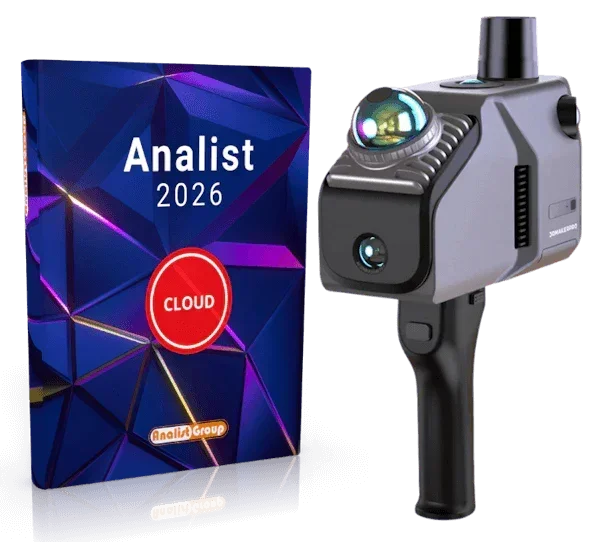
3DMakerpro Eagle LIDAR Scanner
3DMakerpro Eagle LIDAR Scanner
Couldn't load pickup availability


Features and properties
- High-performance LiDAR
- 4 x 48 MP cameras (MAX version)
- 360° x 59° field of view
- 3D Gaussian Splatting
The 3DMakerpro Eagle is a true powerhouse among 3D scanners! Whether you want to digitally capture vast architectural landscapes, create impressive scenes for film productions, or set up virtual exhibitions, the Eagle is your reliable co-pilot and will get you to your destination in record time. Equipped with high-end LiDAR, brilliant 48 MP cameras, and intelligent software, it transforms environments into realistic 3D scenes in an instant. Just unpack it, turn it on, and start scanning!
High-performance LiDAR: greater range, higher accuracy
Thanks to its powerful LiDAR system, the Eagle has a full 360-degree view. It scans at a maximum distance of 70 meters (with 80% reflectivity!) and provides sharp details, with an accuracy of up to 2 cm at a distance of 10 meters. This allows you to easily create not only large-scale models but also entire neighborhoods in record time.
Huge field of view: everything in sight!
Thanks to its 360°×59° field of view, the Eagle doesn't miss a thing! Compared to other scanners on the market, it offers 30% more coverage. With just one motion, you can effortlessly scan entire rooms or landscapes.
Up to 4 cameras for brilliant details
With up to four high-resolution 48 MP cameras (depending on the model → 1 camera for Standard, 4 cameras for Max), it enriches your project with brilliant colors and refined textures. The scanner provides 8K HDR images that effortlessly bring your 3D worlds to life.
3D Gaussian Splatting: from photo to realistic 3D scene
The Eagle transforms your images into realistic 3D scenes using Gaussian Splatting. The data is directly compatible with Unreal Engine and provides high-quality 3D models for games, virtual tours, or film sets.
Virtual and immersive tours
Create breathtaking panoramic tours that make you feel like you're taking a real stroll: thanks to 8K HDR images, you can enjoy the interplay of light and shadow and textures in the highest quality!
Unpack and start: all-in-one solution
Forget complicated calibrations! The 3DMakerpro Eagle is ready to use immediately and saves you up to 50% of preparation time. Just unpack it, turn it on, and start scanning right away. The real-time data visualization on the integrated 3.5-inch display shows what's happening in the live preview.
Flexible and fast on the go
On foot, mounted on a vehicle, or on different platforms, the Eagle is a true all-rounder! With up to 200,000 points recorded per second, data quality remains stable even at speeds of 20 km/h.
Smart software included
Naturally, the Eagle also excels in post-processing. With intuitive software, you can refine your point clouds, export them in formats such as PLY, PNG, OBJ, or Gaussian-Splatting PLY, and share your work with the community.
The standalone modeling software supports you in modeling and surveying point clouds, directly and simply.
Delivery includes:
- 1 Eagle LiDAR 3D scanner
- 1 handle
- 1 PD power adapter
- 1 x 1.5m Type-C Dual-Ended cable
- 1 x 128 GB TF card
- 1 USB-C to USB-A adapter
► Eagle with RTK module. What does it mean?
RTK stands for Real Time Kinematic, a dynamic measurement technology that uses carrier phase measurements to enable real-time differential GPS (RTDGPS). Dual-frequency signals from satellite systems such as GPS, GLONASS, Galileo, and Compass are typically used.
The result? Your point clouds achieve impressive accuracy of up to 1–3 cm! The prerequisite is a base station that communicates wirelessly with the RTK module via L1 (1575.42 MHz) and L2 (1227.60 MHz) frequencies. This ensures precise results even when things get a bit more dynamic.
Technical specifications:
| Eagle Standard | Eagle Max | |
| Dimensions | 115 x 181 x 106 mm | |
| Weight | 1500 g | |
| Accuracy | 2 cm at 10 m distance 3 cm at 20 m distance 5 cm at 40 m distance |
|
| Scan range | 80–140 meters | |
| Scan angle | 360° horizontal 59° vertical |
|
| Point cloud frequency | 200,000/sec. | |
| Laser light source | 905 nm | |
| Laser class | Class 1, IEC60825-1:2014 | |
| HDR mode | supports 3–5 EV | |
| Color texture | 1 x 48 MP fisheye camera | 4 x 48 MP fisheye cameras |
| Image quality | 8K Panoramic Color Output | |
| 2 USB Type-C | 80–140 meters | |
| Connection | Wi-Fi5 | |
| Display | 3.5 inches | |
| Output formats | 3D Color Point Cloud (PLY); 3D Gaussian Splatting (PLY); 3D Colored Polygonal Model (OBJ); 3D Panoramic Tour Data (OBJ) | |
| Battery | 12,000 Ah, integrated | |
NRTK Correction Service Included (Optional)
With the optional TruePoint CM (1 YEAR), you get guaranteed centimeter-level accuracy across all constellations (Full GNSS). An unlimited NRTK correction service for 12 months, ideal for working immediately without interruptions and with maximum reliability.
Shipping and Warranty
Shipping and Warranty
All products available in stock will be delivered with an average timing of 24/48 hours.
Italy warranty with dedicated consulting support, contact us!