GPS ProTrack with Analist
GPS ProTrack with Analist
Couldn't load pickup availability


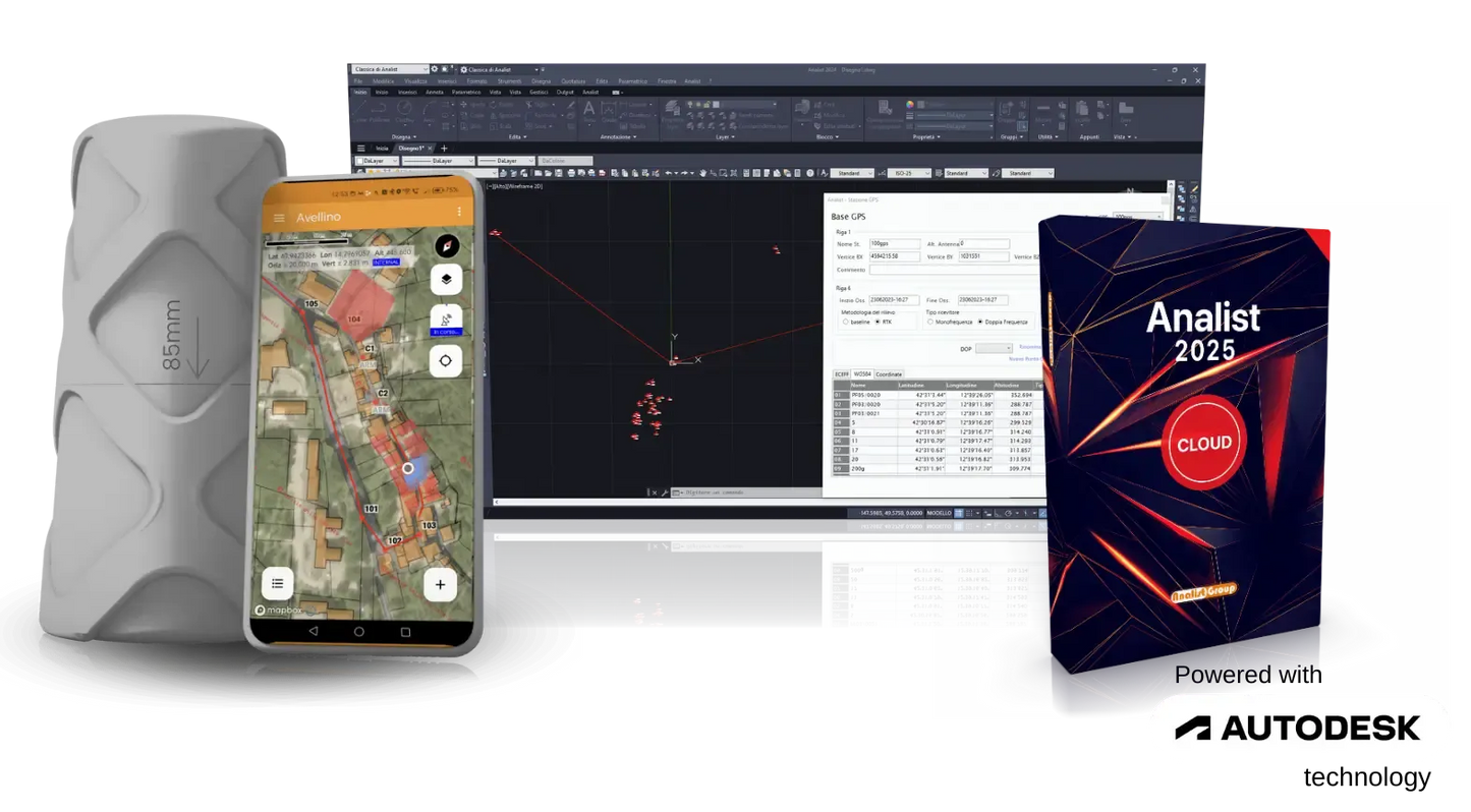
The ProTRACK GPS is a high-precision GNSS receiver developed by
Analist Group, designed to simplify and make work on the
field in areas such as topography, cadastre and precision agriculture.
Simply Powerful
Flexible and easy-to-use GPS in the Turnkey Solution for Surveying.
Includes:
- GPS ProTrack
- Battery Charger
- Analist 2025 CLOUD Annual License
- Mobile Analyst App
- Case for ProTrack
- Access to the ProTrackAcademy Training Platform
- Assistance and Support
● ProTrack Mount for Matterport: €49 + VAT
● Second ProTrack for Base-Rover: €999 + VAT
● Magnetic vehicle mount: €24.99 + VAT
Perpetual license of Analist available on request for institutions
EVERYWHERE
FAST
SIMPLE
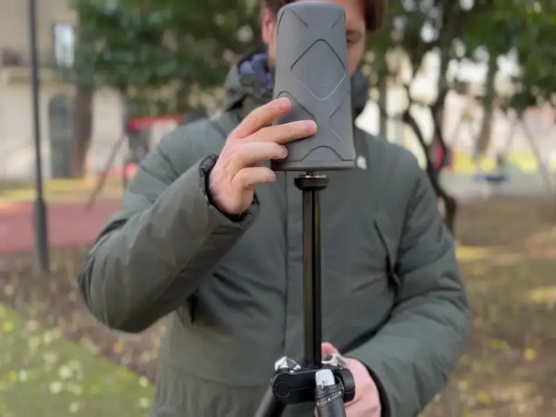
Mobile Analyst
Simple, Intuitive, Powerful
Instant Connection
Survey with centimeter precision
Precise staking
The Land Registry at your fingertips
ProTrack is all this. And much more.
Discover how ProTrack transforms your field work into a unique, precise and powerful experience. ProTrack revolutionizes the world of surveying with a unique combination of advanced GNSS technology, flexibility and ease of use. Whether you are working in the city, in the countryside, or in remote areas without network coverage
- With Analist Mobile , setting up and using ProTrack is immediate.
- It ensures centimeter-level accuracy thanks to RTK technology, NTRIP networks and multi-constellation support.
- Base-Rover mode allows you to get RTK corrections directly from your base antenna, without the need for NTRIP networks or data connections.
- The operating temperature ranges from -40°C to +85°C.
- Up to 18 hours in Rover mode, for a full day of worry-free work.
- Up to 18 hours in Rover mode, for a full day of worry-free work.
ProTrack is adaptable to your needs
ProTrack Rover GNSS
Real-Time Centimetric Accuracy
Leverage RTK network corrections to ensure centimeter-level accuracy in measurements, even in complex environments.
Ideal for high precision topographic surveys, cartography and advanced positioning applications.
Base Rover
For Surveys Without Limits
You can use two ProTrack devices in Base-Rover mode, getting RTK corrections without a network or Internet.
With the BaseQui function, reposition the base freely to cover unlimited areas with precision.
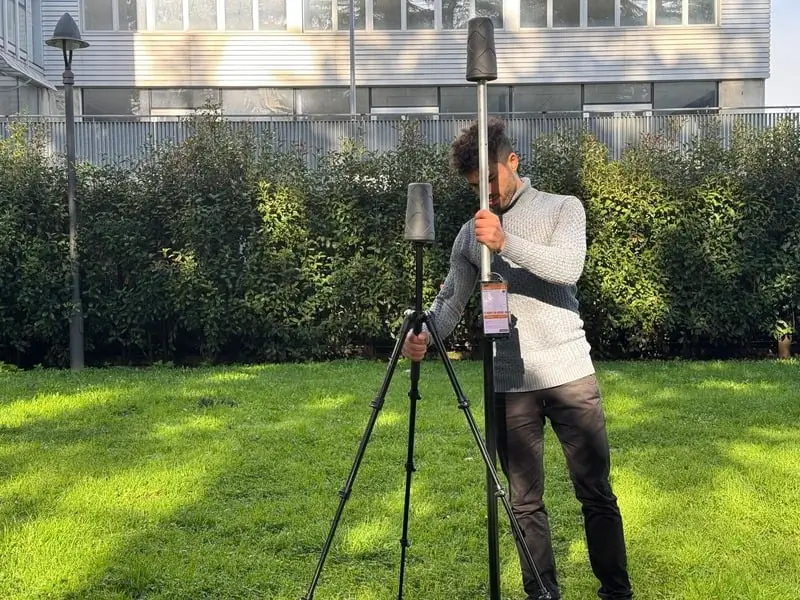
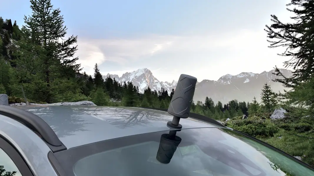
Base + Rover Mobile
The Relief Never Stops
The Base + Rover Mobile feature allows you to use two ProTrack GPS units, one as a Base and the other as a Rover, to acquire points precisely without the need for a differential connection.
Ideal for surveys in unserved areas, it guarantees high quality and accuracy of data in all conditions, even when mounted on vehicles or other mobile configurations.
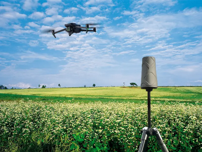
RTK Base for Drones
Maximum Power and Simplicity
The RTK Base provides real-time differential data to drones, ensuring centimeter-level accuracy even in areas not served by RTK.
Essential for high-quality LIDAR and photogrammetry surveys.
Efficiency and Speed for Surveying
He is your right hand man in every situation
Analyst + ProTRACK
The Perfect Integration
Simplify and Optimize
Your Pregeo Practices
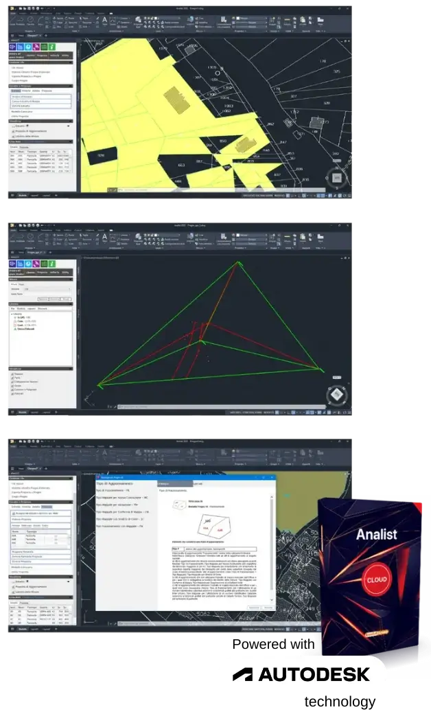
With Analist, powered by Autodesk Technology, you can import surveys carried out with ProTrack for advanced and customizable management of the Pregeo booklet.
What you can do with Analist
- Direct Data Import: Integrate your collected data with ProTrack to start compiling your logbook right away.
- Intuitive Modifications and Additions: Customize and enrich the booklet with useful elements for practice.
- Export Ready for Pregeo: Generate a complete and technically compliant practice, ready for use.
The Management
Of the Topographic Survey
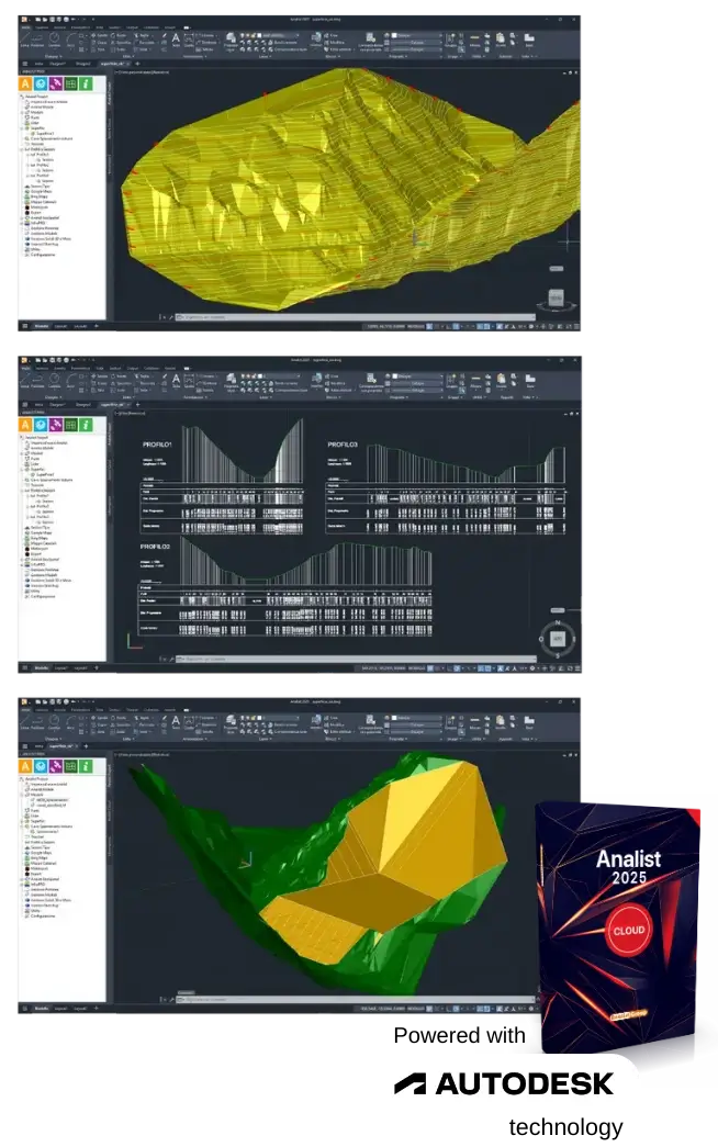
With Analist, powered by Autodesk Technology, by importing data acquired with ProTrack, you can transform your surveys into detailed 3D models ready for analysis.
Main Features
- Point Triangulation: Automatically generates the 3D model of the terrain.
- Advanced Analysis: Extract essential information such as contour lines, profiles and sections.
- Volume Calculations: Quickly obtain volumetric data for excavation or backfill projects.
- Leveling Simulations: Plan and optimize leveling operations.
- Export for Tracking with ProTrack: Data modified or added in Analist can be exported back to ProTrack for tracking in the field, ensuring continuity between design and survey.
ProTrack Technical Specifications
Here is a detailed description of the Technical Specifications of the Instrument: from the Module Type to the Operating Conditions.
- <1 cm with base station up to 35 km
- <1 cm with NTRIP up to 35 km
- <4 cm with SSR corrections
- <1.5m in standalone mode
- <0.9m in autonomous mode with SBAS coverage
- GPS: L1C/A, L2C
- GLONASS: L1OF, L2OF
- Galileo: E1-B/C, E5b
- Beidou: B1I, B2I
- QZSS: L1C/A, L2C
- SBAS: WAAS, EGNOS, MSAS, GAGAN, SouthPAN
- Urban environment: up to 350 m
- Rural environment: up to 750 m
- RF Line of Sight: Up to 3,000m
Shipping and Warranty
Shipping and Warranty
All products available in stock will be delivered with an average timing of 24/48 hours.
Italy warranty with dedicated consulting support, contact us!
-
Free shipping, return in 14 days *.
DisclosureFree express shipping for orders over € 499.
* For return terms and conditions, please visit our returns and refunds policy.
-
-
Are you a professional or a company?
Contact usYou can ask us for an invoice for your purchases! All the prices of our products already include VAT.
-
Do you have the teacher's card?
Contact usProceed with checkout and select "Teacher's Card" as the payment method. Requests?